SAN CRISTOBAL DE LAS CASAS: SYMBOL OF CHIAPAS

On January 1, 1994, the streets of San Cristóbal de Las Casas, symbolic city of Chiapas and the ancient capital of the southernmost state of Mexico,were invaded by the EZLN and that revolutionary air is still felt everywhere.
The Zapatista Army of National Liberation showed up to the world that day and if you like a direct contact with them you have to come to San Cristóbal de Las Casas.

Since decades, also for this reason, the city has become a base for travelers from all over the world, who share their cultures with the descendants of the Original Peoples of Chiapas: Maya, Tzotzil, Tzeltal, Chol.
Here, besides Spanish, millennial languages ​​are still spoken.

Life goes slowly in the cobbled streets of San Cristóbal and slowly you have to know it.

In my travels I like to discover cities using a paper map , often taken in hostel.
When I go back to my room, I highlight the streets where I walked to go to others streets and see as much as possible.
I use some landmarks, places that I consider strategic for various reasons.
In San Cristóbal I have identified two of them: the Cathedral and the market..


Catedral and Plaza 31 de marzo

This area has become my base in San Cristóbal.
When I arrived here, I realized I was really in Chiapas.
The cathedral is colonial-style, very different from the classic Catholic churches I’m used to see.
Unfortunately, it is not currently possible to access it because the restoration of the damage caused by the 2016 earthquake continues.
And unfortunately it is not new: started in 1528, it was finished only in 1815 due to various natural disasters.
In 1816 and 1847 it suffered other damages with consequent restorations.

Mexico-San-Cristobal-de-las-Casas


Mexico - San Cristóbal de Las Casas - Cathedral


The Cathedral Square is often full of local inhabitants, travelers, stalls and indigenous people of the city and neighboring villages, dressed in their traditional clothes.

Children play, but more often they wander the city trying to sell bracelets or other handicrafts.
And precisely in this context I experienced one of those episodes that teach that traveling opens the mind, give the true values ​​of life, helps to grow and be better..


Mexico - San Cristóbal de Las Casas

One hot Chiapanec afternoon, I was sitting having lunch on one of those tables in the shade, watching life slowly pass in front of me.
One of the many children who fill the streets of San Cristóbal approaches me to sell me a bracelet made by him.
I smile and tell him that if he wants I can offer lunch. He doesn’t wait I repeat it, he sits down and orders a sandwich and a coke.
After a while another child arrives and he sees one of his contemporary, at that moment luckier. He looks at him with healthy boyish envy and seems to savor that sandwich and refresh himself with coke.
I also invite him to sit down with us but he refuses because his mother is sitting on a bench nearby and doesn’t want to betray her.
I tell him that if you want, I’m glad that she comes.
The boy runs to her and they go back to the table together. Hunger probably made her put aside all hesitation.
I order steaks for everyone, as big as they may have never eaten in their life.
Se tries, but doesn’t know how to use cutlery.
I immediately avoid getting embarrassed and we eat all four with our hands, with humility, with respect.
The children also speak Spanish, the lady only indigenous language.
We speak, children translate. And where words stop, we understand each other with looks and smiles.
Then everyone goes their own way.
With full stomachs and fuller hearts.


Mexico-San-Cristobal-de-las-Casas


San Cristóbal for me are cobbled streets full of people, the perfume of chiapanec coffee, the cultures that coexist and that also merge in food, the colorful houses like traditional clothes, the hot morning sun and the cold that become pungent at night because here, however, we are at 7.200 ft above sea level.


Mexico - San Cristobal de las Casas


Iglesia del Cerrito (o San Cristobalito)

On the Cerro San Cristóbal hill, there is the Iglesia del Cerrito.
Reachable by a particular zigzag staircase, it allows you to see the city landscape.


Mexico - San Cristóbal de Las Casas - Iglesia del Cerrito


Mexico-San-Cristobal-de-las-Casas


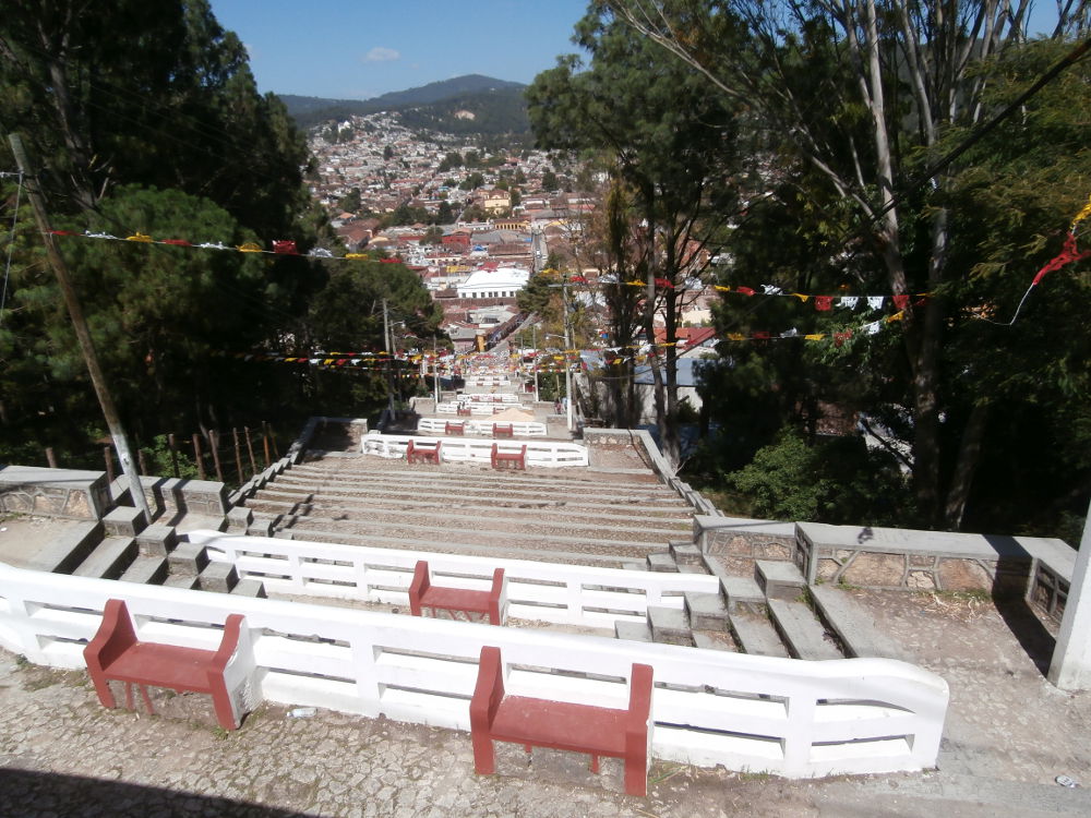
On the other side there is the Cerro de Guadalupe, with the church crowded especially on December 12, the day of Our Lady of Guadalupe.


Templo de Santo Domingo

Built in the 17th century in the Chiapanec Baroque style, the temple and ex convent of Santo Domingo surprises and impresses with its pink facade.

Mexico-San-Cristobal-de-las-Casas-Templo-de-Santo-Domingo


Near there is the city market, a meeting point for colectivos.
Cars, minivans or more or less equipped camion (as in the photo below), connect San Cristóbal with neighboring cities and towns. They are the perfect transport way for small-medium range travel.
Depending on the destination, they will leave when the vehicle is full or will pick up people on the way.
The price changes depending on the distance but will always be cheap and convenient.


Mexico - San Cristobal de las Casas


At the market you can find everything at very cheap prices, from food to clothes or crafts to take home.
You could negotiate the price but you always have to think if few pesos saved change your life..
Those few extra pesos can instead help someone to feed their family.

Because Chiapas is wonderful, but it’s also the poorest Mexican State.


Mexico-San-Cristobal-de-las-Casas

HISTORY OF THE CITY

About 2400 years ago, the Valley of Teotihuacan was occupied by various rural communities with a population of approximately 5,000 inhabitants.
Toward 200 b.C., part of the population from the Southern Basin of México, immigrates to the north of Lake Texcoco and formed a new population center, giving rise to the first planned urban settlement in Mesoamerica.

Mexico - Teotihuacan

Mexico - Teotihuacan

During the following phases of the development of the city, a sophisticated level of urbanization was reached as demonstrated by an urban plan with streets and blocks, dominated by two large perpendicular roadways running through them: the Avenue of the Dead and the East-West Avenue. Likewise, the city had a drainage and a sewage system in the residential units, buildings and public squares.
Its architectural style was characterized by slope panels.
The temples and palaces that limit the Avenue of the Dead were the political-administrative and civic-religious areas; while the residential units of the upper classes were located in the surroundings. Ordinary people lived on the suburbs.

At its peak, between 450 to 650 a.C., the city occupied an area of approximately 14,3 sq. mi,, with a population of 175,000 inhabitants. The demographic increase, the economic development, the high level of specialization and an important expansion in the arts and sciences generated great social differences.

The principal element of the government was religion. It dealt with a theocratic society with controlled not only the Valley of Teotihuacan, but the neighboring valleys of the Basing of Mexico as well.

Teotihuacán grew on top of itself during nine centuries, so we could see different levels of constructions which correspond to different stages in the development of the Teotihuacan culture, until its fall around 700-750 A.D..
After the city was abandoned and until the arrival of the Spanish, various cultural groups, such as the Toltecs and the Aztecs, respected it as a sacred city. Settlements established themselves on the outskirts, reoccupying the residential zones and the spring fed agricultural areas.

The true name of the ancient city is unknown, but the current one is in the Nahuatl language and is due to the Aztecs.

THEY WERE NOT MAYANS OR AZTECS: THEY WERE TEOTIHUACANS

Sometimes, people confuse the pre-Hispanic history and mix information from different times and different places.
So, we think that the Aztecs built Teotihuacan.
But no, they lived in Central Mexico, but so many centuries after this city was abandoned.
Teotihuacan is also not related to the pyramids of Egypt or other distant civilizations.
And also if the origin of its inhabitants and their language are unknown, today they are known simply as Teotihuacans.

THE PYRAMID OF THE SUN

The Pyramid of the Sun is the largest pre-Hispanic building of its time (AD 100-650) and one of the most important in Mesoamerica.

Mexico - Teotihuacan

Mexico - Teotihuacan

Its name is due to the fact that, since the sixteenth century, the chronicles mention that this great monument was dedicated to that divinity.
In 1905 Don Leopoldo Batres began his big exploration, by order of Don Porfirio Díaz. The purpose of this was to highlight the cultural greatness of the Mexican people through their pre-Hispanic works and to commemorate, in 1910, the Centenary of the Independence of Mexico.
Archaeological investigations indicate that its construction was carried out in a single operation and demonstrate that its interior is full of sand and country land. The tunnels that can be seen on its sides have been made by various researchers in order to learn about its history and its construction system.

Mexico - Teotihuacan

The top of the pyramid was crowned by a temple where religious activities associated with the divinity to which this building was dedicated were carried out.

This pyramid was the base of a great temple dedicated to a deity whose dedication was the Sun.
A new interpretation proposes that the deity worshiped in this building was Tlatoc, the god of water.

THE PYRAMID OF THE MOON

The Pyramid of the Moon has a rectangular plan, it is 150 meters long on its east-west axis and 130 meters on the north-south, with an actual height of 42 meters.
A protruding body is attached to the front of the pyramid, larger than that of the structure attached to the front of the Pyramid of the Sun and which doesn’t appear to overlap, but is part of the same construction.

Mexico - Teotihuacan

Mexico - Teotihuacan

This structure has four staggered bodies with walls on a board slope. On the sides of this superimposed body, there are two large drainage channels limited by sidewalls.
As in the rest of the pyramidal foundations observed in the Archaeological Zone, in the upper part there must have been a temple, which, according to the data of the excavations carried out on the site, seems to have consisted of a single bay divided into three parts.
At its peak, the Pyramid of the Moon was painted red and dedicated to the goddess of water and fertility.

SQUARE OF THE MOON

One of the most important sacred spaces within the city of Teotihuacán is the one that includes the Pyramid of the Moon, its large square, the bases and structures that make up the entire complex.
It is in a strategic position in the entire urban setting, since it is the point where the main axis of the city begins, namely Avenue of the Dead.
Another feature of this area is that it presents an open perspective, unlike those of the Pyramid of the Sun and the Citadel, which are spaces limited by a platform.
In this sense, it is probably a place dedicated to public ceremonies, without restrictions for access to the entire community.
The main square in front of the Pyramid has a quadrangular plan, with a length of 140 meters per side and with the symmetrical position of the buildings on both sides of the axis of the Avenue of the Dead.
In its central part it has a large altar with steps leading to the four directions.

Mexico - Teotihuacan

In front of the Pyramid of the Moon, there is a structure divided internally into five parts, which takes the name of “Teotihuacana Cross” or “Quincunce”.
The Quincunce in Mesoamerica is associated with a cosmological order of long tradition, in which the universe is divided into four regions, each governed by a cardinal point and in the center converge the power of the four corners of the cosmos and the three vertical levels (sky, earth and hell): the navel of the world.

THE AVENUE OF THE DEAD

The Avenue of the Dead is the main street in the city of Teotihuacán.
It has a south-north direction with an orientation of 13°25′ towards the east, compared to the astronomical north.

Mexico - Teotihuacan

Mexico - Teotihuacan

Mexico - Teotihuacan

Its northern end is Piazza della Luna and its southern end has not yet been explored.
Exceeds 4 km in length.
Perpendicular to it and the city center, the East-West Avenue divides Teotihuacan into four.
From both streets, the urban structure is carried out in such a way that the streets and the general orientation of all the buildings are parallel and perpendicular to them.

A COSMOPOLITAN CITY

Like many large cities today, Teotihuacan was a multicultural city, it represented a place of great importance in a vast territory, because its political, economic and religious influence reached faraway places.
Likewise, people from different regions come to live here.
Archaeologists have found neighborhoods of Zapotechi (Oaxaca) and groups from the Gulf coast (Veracruz).
Even today Teotihuacan continues to attract people from different parts of the world, because the archaeological area is considered a World Heritage Site.

It is difficult to know for sure which language or languages ​​were spoken in Teotihuacan, there are different ideas about it.
There are those who think it was a variant of Nahuatl, others think that Otomí was spoken, that there were Nahua-Totonac, Mazateco-Popoloca groups or other languages.
However, even if we don’t know it, that demonstrates the cultural richness and linguistic variety that existed in Mesoamerica.
Today dozens of indigenous languages ​​are spoken in Mexico. They have the same value as Spanish and are recognized by the Constitution.
Remember that indigenous languages ​​are real languages!

ASTRONOMY

One way to calculate the time was to observe a ray of sunshine inside a cave.
Several natural caves have been found in Teotihuacán, organized to be dark rooms, where the solar lighting inside them allows you to recognize some astronomically important moments.

Mexico - Teotihuacan

At 270 meters from the Pyramid of the Sun, there is a 4 meter deep cave.
Inside, a small stele was found set vertically in a clay altar. The position and width of the solar beam inside the cave indicate the solstices, the equinoxes and the days when the sun reaches its zenith.

Mexico - Teotihuacan

THE TEOTIHUACAN WRITING

Teotihuacan’s writing represents a language still unknown, since none of its signs has been completely deciphered and we don’t know exactly what his reading order was.
Topics covered in this writing system include dates, high-ranking titles, proper names, names of deities, geographic locations, names of some games or dances and probably short linear texts or arranged in columns separated by red lines.

MAGDALENFJORDEN: LIKE AN EXPLORER

Before start this travel, crossing the geographical limit of the 80th parallel North was one of the objective of my trip.
At Magdalenfjorden you can swim in the icy waters of the Arctic Ocean. That’s why I was looking forward to this day of expedition on the Hurtigruten. Read more

NY ALESUND: TRAVEL WITH SCIENTISTS

About 30 people live in Ny-Ålesund in winter and 130 in summer.
This settlement on Svalbard seems an international territory, a world fundamental scientific base especially for geologists and meteorologists.

Read more

TRIP TO BARENTSBURG

THE USSR TO THE SVALBARD ISLANDS

Barentsburg (in Russian language Баренцбург) in winter is reachable by snowmobile, in summer is the first stop of the Hurtigruten expeditions but you could visit it also with a daily tour from Longyearbyen.
This is the only mining settlement dating back to the Soviet period still operating on the Svalbard Islands and has an important geopolitical value.

Read more

TOUR TO PYRAMIDEN FROM LONGYEARBYEN

FINDING THE URSS AND POLAR BEARS

After the polar expedition with Hurtigruten to overcome the 80th parallel north, I chose a full day tour from Longyearbyen to Pyramiden and the Nordenskiöldbree Glacier, the last chance to see animals, absent in the previous days.
And incredibly it was the perfect choice.

Read more

LONGYEARBYEN: TRIP TO THE END OF THE WORLD

Gate 20 is on the lower level of Tromso airport and walking in the grey corridors seems to have already left Norway.
The passage to customs for passport control marks the exit from the Schengen areaand leads to the waiting room.

Read more

SVALBARD ISLANDS: TRIP TO THE NORTH POLE

I have always liked geography and I often find myself digging into memories looking for unusual and unknown destinations for future trips.
It is in one of these researches that the Svalbard Islands have become the enlightening destination.

The islands under the Norwegian flag, often even hidden by the arm of the earth’s axis in the globe, are the northernmost inhabited lands on our planet..

Read more

HOW TO BE THE NORTHERNMOST PERSON IN EUROPE

We think that North Cape (or Nordkapp) is the northernmost place in Europe, beyond which we cannot go.
This could be true if we did not consider some islands and lands covered mainly by glaciers.
But even in this case the name pushes us to error.

If you are in the balustrade near the famous globe’s sculpture and look the sea thinking to find only the infinite sea in front of you, you will be very surprised.

Read more

HOW TO GET TO NORTH CAPE (FOR TOURISTS)

The name North Cape immediately suggests that reaching it represents a fundamental stop in our life, or at least in the experience of travelers.

Imagining yourself here at the end of the world can be true, even if only in part.

Read more

CRUISE IN THE NORWEGIAN FJORDS AND SVALBARD

As an islander I have always seen ships as a means of transport to reach what in Sardinia we call “the continent”.
My style of traveling is very different from seeing a ship as a comfortable hotel/restaurant on which to spend most of the time, as if the portu cities were only a secondary interlude between a meal, a dance, a karaoke song, a dip in swimming pool and well-deserved rest at the end of the day.

The Hurtigruten can be used in both ways, so I have chosen it.

Read more

NATURE AND LEGENDS OF THE GIANT’S CAUSEWAY

NATURE AND SCIENCE

The Giant’s Causeway, a UNESCO heritage site since 1986, is an expanse of about 40,000 basaltic columns, mostly hexagonal, up to 28 meters high.
Science teaches us that over 60 million years ago, a submarine volcanic eruptionbrought to the surface a large lava mass that, in contact with wind and sea, cooled quickly, solidifying, contracting and generating the cracks that gave rise to these particular columns.

This is the Giant’s Causeway, constantly changing because column movements.


The Giant's Causeway - Ireland - basalt columns


The Giant's Causeway - Ireland


Ireland - The Giant's Causeway - Giant's foot


THE LEGEND OF THE GIANT

Obviously this particular place can inspire a lot of legends.
One of the more known is about Fionn mac Cumhaill (name often Anglicanized in Finn McCool).
The gentle Irish giant built the road to reach Scotland and fights against rival giant Benandonner.
After building the causeway, tired from the great work, Fionn fell asleep.
he next morning, Fionn’s wife, Oonagh, found her husband snoring and heard the thunderous sound of Benandonner’s footsteps crossing the causeway. He was really huge and Fionn would have no hope of defeating him.
So Oonagh decided to put a nightgown on Fionn asleep to make him look like a child.
When Benandonner arrived home, he asked to meet the cowardly rival but Oonagh asked him not to scream or he would wake his son.
Benandonner, seeing the size of the “child”, worried about how great Fionn could be and so, frightened, he fled to Scotland destroying the causeway behind him.


if the chimneys are smoking The Giant's Causeway - Ireland


Humphrey the camel - The Giant's Causeway - Ireland


Humphrey the camel - The Giant's Causeway - Ireland

VISIT THE GIANT’S CAUSEWAY

The entrance fee costs £ 10, including the multilingual audio guide necessary to understand the origin of this particular site and the legends that surround it.
You can reach the columns either with a panoramic walk or with a bus (for a fee).
At the Visitor Center, sustainable and with an original structure that brings back to the basaltic columns, there is a bar and a souvenir shop.


beach - The Giant's Causeway - Ireland


HOW TO GET

Car

Outside the visitor center, big parking is available


Public transport

If you don’t have a car, public transports are a great way to come here.
Spending £ 17 for the iLink Zone4 allows to use trains and buses for 24 hours.

The city of Coleraine is the hub of connections with Belfast (buses 218) and Derry (buses 234).
From here you get on bus 172, direction Ballycastle, and get out at The Giant’s Causeway stop, 150 meters from the entrance to the Visitor Center.


Wind on the cliffs - The Giant's Causeway - Ireland

TRIP TO DERRY/LONDONDERRY:

TELL ME THE NAME OF YOUR CITY AND I’LL KNOW ABOUT YOU

To understand this part of Ireland it is necessary not to stop in Belfast.
Visit Derry is essential to understand the historical, ideological and cultural divisions that separate the inhabitants

Read more