FESTIVAL OF SAN FERMIN:
RUNNING OF THE BULLS IN PAMPLONA

We have all heard about the running of the bulls in Pamplona during the festival of San Fermin.

What exactly are the festival and the running?
I’ve been there four times and I think I know enough to explain everything and answer your questions.

Euskal Herria - Iruña/Pamplona - San Fermin

INTRODUCTION

The bull run, the “encierro”, is a free 850-metre race with 6 wild bulls and 6 cows leading the herd, which is celebrated in Pamplona every day from 7 to 14 July each year, for the San Fermin festivity.
The launching of a rocket starts the race at 8 a.m. and its estimated duration is between 2 and 3 minutes.
When it exceeds 3 minutes, it usually means that the bulls are not together but are running alone, so the danger increases exponentially.

Everyone over the age of 18 can take part in the run, free of charge and without registering, subject to rules that we will see later.

HISTORY

Birth of the bull run

Historical reports report that in the 1385, during the reign of Carlos II de Navarra, primitive bullfighting was already being celebrated in Pamplona.
At that time, the bulls were led on foot through the fields to the city and the last leg of that trip was made early in the morning, running through the streets cheered on by the shepherds.
We have to conclude, therefore, that at least 600 years ago there was an embryonic bull running in Pamplona, which began as an accompaniment of the bulls through the streets of the city to the bullring.

Those bull runs had little to do with the current ones. A galloping horseman would stand at the front to announce the arrival of the bulls to the inhabitants, and some young men would run with the herd, contravening the orders of the consistory, which always considered the bull running as disobedience to authority. The run was officially forbidden, although it was permitted.

In the Middle Ages the streets were delimited by blankets and carts, until in 1776 the municipality decided to place a pine fence to prevent the frequent cases of bulls running through the streets of the city.

Until 1843 the bull run ended at Plaza del Castillo, temporarily set up as a bullring, and until 1856 the bulls didn’t run down Calle Estafeta.
During those 13 years, the bull run had four different routes, partly because of the construction of the railway.
It would have allowed the bulls’ transport by train, excluding the trip through the countryside and the subsequent bull run in the streets.
Popular support for the Pamplona bull run defeated the authorities’ desire to ban it definitively, prompting the city council, in 1867, to establish a rule fixing the time and route, making it legal.

The last big change to the route of the bull run took place in 1922, when the inauguration of the current bullring obliged the bulls to turn left at the end of Calle Estafeta, instead of turning right as they had done until then.

Record-breaking bull runs

Although it may seem strange, never one bull run is the same or similar to another, given the infinite variables created by the bulls, the runners and the weather.

However some races have been remarkable.

On July 8, 1939, a bull named ‘Liebrero’ broke through the fence causing numerous injuries and was killed by the Guardia Civil.

In 1940 a bull broke the fence in the Telefónica area and escaped after goring a spectator.
In 1941, the strength of the fence was increased, making it double: another fence was added to the first one, spaced two metres apart.

The bull runs of 10 July 1947 and 13 July 1980 were the only ones in which the same bull killed two people.
They were ‘Semillero’ and ‘Antioquio’.

The longest bull run took place in 1959 and lasted about half an hour.
A bull in the bullring didn’t want to enter the stable, until a small German shepherd succeeded and was acclaimed by the entire arena.

On 12 July 1988 a bull ran all the way through Santo Domingo in reverse, returning to the stable door.

On 9 July 1994, there was the highest number of people injured, although not seriously: 107.

The fastest bull in Pamplona was ‘Huraño’, who on 11 July 1997 finished in just 1 minute 45 seconds.

In 2003 a bull gored a father and his son in less than 20 metres.


Euskal Herria - Iruña/Pamplona - San Fermin


ROUTE

The 850-metre-long Pamplona Encierro runs through the winding streets of the city’s historic centre.
The urban complexity of this area of Pamplona, the result of centuries of different constructions, makes the route of the bull run so varied and spectacular that it seems to have been designed especially for the Encierro.
In fact, it runs through medieval gates, steep climbs, double right-angle bends, narrow and shady alleys, fast descents and enters the bullring through a gallery of terraces.

Shortly before 8a.m., runners go near the start, where there is a small statue of San Fermin, and entrust themselves to him with the singing, first in Spanish and then in Basque language:
“a San Fermín pedimos, por ser nuestro patrón, nos guíe en el encierro dándonos su bendición.

Entzun arren San Fermín, zu zaitugu patroi, zuzendu gure oinarrak, entzierru hontan otoi.

Viva San Fermín. Gora San Fermín”.

Then at 8 o’clock a first rocket starts the race.

Santo Domingo

The bulls come out of an enclosure located in an old bastion of the walls (a second rocket signals that all the bulls are in the route) and, rested, they reach the highest speed of the entire route in the Santo Domingo climb: 280 metres between stone walls at a 10% drop.

San Fermin Pamplona - Santo Domingo

Plaza del Ayuntamiento – Mercaderes

The second section of the bull run is flat and measures 100 metres long by 9 metres wide.
The bull run is still very fast, skirting the town hall and taking a slight left turn at the beginning of calle Mercaderes.


Estafeta

Difficult section of the race: 300 metres in the shade and a slight climb of 2%.
There is a 90° bend to the right, which, due to the centrifugal force, often results in the bulls colliding against the outer fence, causing chaos and the subsequent separation of the herd.
Runners here must be very careful and avoid the left side.
It’s easy the bulls separate at the Mercaderes bend so is impossible to manage them all the way down Calle Estafeta.
Some bulls will overtake you and you have to move to one side cleanly and without damaging other runners.
Be careful about the horns of the bull that surpasses you and another bull may be behind you.


Telefónica

The last section of the encierro is the brightest and the only one slightly downhill.
In the 90 metres of the Telefónica segment, the bulls are tired and run more slowly than in the beginning of the route, but they are often alone and cross an area without buildings, with fences on both sides.
The danger is also increased by the presence of inexpert runners, who don’t follow the acceleration of the bulls.
This creates very dangerous situations and in fact the accident statistics are particularly high.


Callejón

The 9-metre width at the beginning of the Telefónica narrows in a funnel shape to the 3-metre Callejón (alley) of 30 metres that passes under the stands, all the way to the inside of the bullring.
The main danger is the formation of a block between people trying to enter and the bulls, which usually has no difficulty in overwhelming everyone and making its way through.

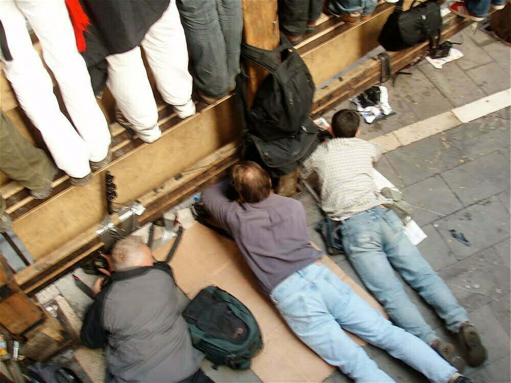
In case of a fall, the runner should escape by rolling sideways, avoiding being trampled and above all not getting up, so as not to be run over by the crowd or gored by the running bulls.
You should not enter the arena behind the herd because the bulls often turn around and the runners get stuck between the bull and the gate.


Plaza de Toros

When all the animals enter the bullring, the gate is closed for safety and a third flare warns that no bulls are left in the street.

Once inside the bullring, taking care of the change of pavement from cobblestones to sand, it’s important to open up immediately by fanning out to the left or right towards the barriers.
This helps the bull to go straight towards the fence, possibly guided by the dobladores, dressed in green and with the banner draped over the ground.

The entrance of the last bull into the corral, with fourth and final rocket, marks the end of the daily bull run.


PROTAGONISTS OF THE BULL RUN

Bulls

In classical antiquity, the bull was always considered an animal that embodied the characteristics of the gods: greatness, strength, courage and nobility.
Humans, seeking to be similar, have been challenging bulls for thousands of years, from Greece to Crete and Anatolia.
The Pamplona bull run is nothing more than a local modern manifestation of defiance to death, represented by the bull.

Wild bulls are bred in large areas of Andalusia, Extremadura and Salamanca, but there are also some herds in the provinces of Madrid, Navarre, La Rioja and Aragon.
Each bull reared requires one and a half hectares of land, and each kilo of adult animal consumes 60 kilos of grass or 15 kilos of hay.
The bulls that run in Pamplona weigh between 600 and 700 kilos and are chosen from the best for their size, gait, horns and pride.
Despite its torpid appearance, the bull is a very strong, agile and fast animal.

Runners

In the bull run there are many elements and people who help in the organisation or in its safety, but there are only two protagonists of the race: the runners and the bulls.
Without them the bull run would be impossible, without all the others it would be more unsafe, but it could be realised.

To take part in the run, you neither have to pay nor register, you just have to be on the route before 07.30.

An estimated 2,500 people run on weekdays, 4,000 on weekends.
Not everyone can be considered a runner: more than 1,000 stay hundreds of metres away from the bulls, another 500 run close to the herd, but when the bulls are about five metres away, they move to the sides and stop.
The rest run in the front row, feeling the breath of the bulls behind them, switching between them in stretches of about 40-50 metres and with runs that last no more than 8-12 seconds in front of the bull’s muzzle.

70% of participants are between 20 and 35 years old, about 10% under 20, and the remaining 20% over 35, with some veterans in their 50s or 60s.
About 40% are from Pamplona or Navarre, 30% are Spanish and the rest are foreigners.

The run lasts approximately two and a half minutes, and no one, even a true athlete, can run the full 850 metres next to the bulls because of the confusion generated by running pushes, slower runners to dodge, people falling on the ground to jump over and, of course, animals to be constantly watched.


Shepherds

Shepherds have always been present in the bull run because in the Middle Ages, when there were no runners yet, they drove the cattle on foot through the countryside and in the streets of Pamplona.

There are currently between eight and ten shepherds in the bull run, identifiable by their identifying green uniform “pastores” and a rod in their hand.
Each of them is assigned a section and they change every 100 metres or so. Their job is to prevent the herd from scattering and the bulls from turning back.

Shepherds are experts in handling non-domesticated cattle but almost none work in cattle breeding or bullfighting.


Dobladores

The figure of the dobladores arose in the 1930s to provide greater security at the end of the bull run.

There are currently four dobladores in the Pamplona bullring, often former professional bullfighters or those with great experience in the Pamplona bull runs.

The dobladores are in charge of dragging a red drape across the sand to help the disoriented bull reach the corral, thus avoiding endangering the many people in the arena in the final moments of the race.


Workers

Excluding runners and spectators, about 650 people work for the Pamplona bull run, demonstrating the importance of organisation.

150 municipal and provincial police officers take care of clearing the route of people who are not runners but who populate the streets after the night of revelry, contain the runners at the start at the beginning of the Santo Domingo ascent and enforce the municipal regulations on bull running.

Coordinated by SOS Navarre, 200 members of the Red Cross and DYA (Medical Assistance) take care of the medical care of the slightly injured and the transfer of the more seriously injured to hospital.
There are both 15 posts along the route and 15 medical ambulances.
There are two operating rooms ready in the arena, as well as in the two public hospitals in Pamplona.

San Fermin Pamplona - carpenters

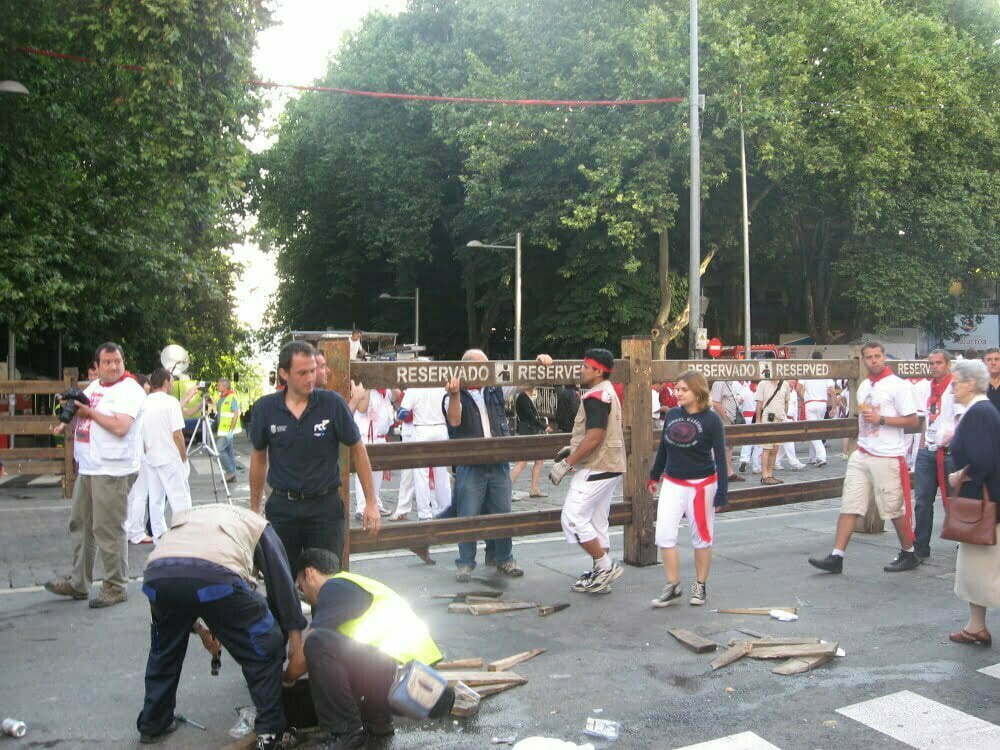
The 40 carpenters and joiners who assemble and dismantle the fences on a daily basis also do a crucial job.
Installed on both sides of the streets and in unbuilt spaces, they are made up of around 13,000 pieces including screws, washers, wedges and, above all, 900 vertical poles and 2,700 horizontal boards.
They are marked with letters and numbers so that each piece is placed in the same place year after year.
In certain sections of the route, the barriers are fixed. They are installed towards the end of June and remain until the last day of the San Fermin festival.
In other sections, where vehicles pass by, they are erected and dismantled every day.


San Fermin Pamplona - fence

All the horizontal planks and vertical posts, which are anchored to the ground in holes 40 centimetres deep, are reinforced with metal covers to withstand possible impacts from bulls.

In addition, there are 12 doors, also reinforced, that close as the herd passes, to prevent the bulls from coming back.

San Fermin Pamplona - fence carpenters

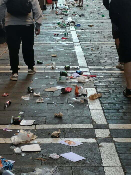
Street cleaners work both in the 850 metres of the bull run just before the race and several times throughout the city, because of the huge amount of waste produced.

San Fermin Pamplona - waste

In addition, there are at least 200 accredited professionals from the press, radio, internet, television, magazines, photographers, reporters and tv technicians, national and international.

San Fermin Pamplona - photographers


HOW AND WHERE TO SEE THE BULL RUN

The Pamplona bull run is one of the most internationally renowned public spectacles, but one of the most difficult to see in person.
This is because the race is not in an enclosed area, but through the streets of a chaotic city in fiesta.

Therefore, to experience the excitement of the race, you have to arrive a few hours early and stand on the wall near the start or behind the few fences that border the route.
This is the only way to have a chance to be one of the 1,500 people who will see the bulls up close, even if only for a few metres.
You can’t stay between the two fences, because that is the space reserved for people running, health personnel and accredited media.

A privileged viewpoint is a balcony: from there you can see a 100/200 metres stretch of the course and you don’t have to arrive hours in advance.
The problem is that, if you are not family members or relatives of the owners of the houses along the route, you can only get onto the balcony by paying a seat rented for € 100,00 or more per person per day.

The arena has a capacity of 20,000 spectators, but tickets must be purchased in advance.
You don’t see the bull run, but only the final part, with the bulls entering and the runners fanning out.

The last comfortable option if you don’t want to move in the cold Pamplona night, is to watch the race from the television or the giant monitors installed in the streets, as millions of Spanish and international spectators do on the various available platforms.

San Fermin Pamplona - spectators fence

PAMPLONA DURING SAN FERMIN DAYS


San Fermin Pamplona - launch from the fountain

Before living these Pamplona days, people think that the San Fermin festival is just the running of the bulls.
Nothing could be more wrong.
We have seen that the run itself doesn’t even last three minutes. Then there are another 23 hours and 57 minutes….


The procession of the Saint


Euskal Herria - Iruña/Pamplona - San Fermin

According to tradition, the Roman senator Fermin and his family were converted to Christianity through the influence of the presbyter Honestus, who carried out his evangelical work in Roman Pamplona in the 3rd century.
His son Fermín was baptised by St Saturninus, ordained a priest in Toulouse and returned to Pamplona as a bishop.
He spent his last days in Amiens, where he converted more than 3,000 people before being imprisoned and beheaded on 303 September, 25.

In 1386, King Carlos II of Navarre left a relic of the Saint recovered in Amiens in the Church of San Lorenzo, and the procession has been celebrated ever since.
Initially, the Saint was celebrated on 10 October, the date of his arrival in Amiens, but from 1591 the date was moved to 7 July to coincide with the religious festivities in his honour celebrated between St Peter’s Day and 18 July.

The bust carried in procession is a wooden sculpture dating the end of the 15th century, covered with silver in 1687, and on its chest is a reliquary, also made of silver.

San Fermín is the patron saint of the diocese of Pamplona and, together with San Francisco Javier, the patron saint of Navarre, as well as the patron saint of the confraternities of vintners and bakers.

The cult of San Fermín is deep-rooted among the Pamplonians and the saint is invoked during the chupinazo, just before each bull run, several times during the day and in the lamentations of the ‘Pobre de mí’ at the end of the fiesta.
This is a tradition transmitted from generation to generation.

The procession of San Fermin is held on the morning of 7th July and is an essential act for many Pamplonians, so it is also a must for foreigners to get to know the fiesta in all its solemnity.
After a procession from the Cathedral to the Church of San Lorenzo, the statue of the saint crosses the city, enveloped in the devotion of the Pamplonians and those who make the following days unique: clergy, masks, brotherhoods, bands, dancers and authorities. Obviously all dressed in traditional attire, always with a white shirt, trousers or skirt, sash and red kerchief.
City councillors wear a top hat, gloves and a medal with the city’s coat of arms.

During the morning there are many emotional moments between prayers, singing, dancing and parades, accompanied by La Pamplonesa, the city’s musical band, but also by spontaneous groups.

The masks parade


Euskal Herria - Iruña/Pamplona - San Fermin - Gigantes y Cabezudos

The parade of the 25 masks of the Giants and Cabezudos (Giant Heads), accompanied by the music of the Gaiteros (pipers), has become one of the symbols of the San Fermin fiestas.

These figures have always been present in the important celebrations of Pamplona since the 16th century.
In 1800 this tradition was lost, recovered a century later thanks to the six giants conserved in Pamplona Cathedral.
The papier-mâché sculptures that currently depict the giants were created by Tadeo Amorena in 1860, commissioned by the municipality of Pamplona.

The dancer carries the figure on his shoulders, which weighs about 60 kilos and reaches up to 4.20 metres in height.

San Fermin Pamplona - masks

The parade starts every morning from the bus station at around 9.30 am, except on the 6th at 4.30 pm.
The route runs through the streets of the old town, but changes every day.

At the head of the parade are 5 Cabezudos, huge heads with serious faces representing authority.
They are known as the Mayor, the Municipal Councillor, the Grandmother and a Japanese couple.
They walk with a solemn gait and shake hands with all the children who ask.

The 4 pairs of Giants represent a king and queen from each Continent: America, Africa, Europe and Asia (when they were born, Oceania was not yet known).

San Fermin Pamplona - masks

The Kilikis have grumpy faces, a hat and a plastic pole with which they hit children.
They are called Barbas, Caravinagre, Coletas, Napoleón, Patata and Verrugas.

The Zaldikos simulate armed horsemen with their rods, wandering the boys they meet on their way.

On 14 July, the last dance takes place in the bus station, in a very emotional moment called the Despedida de los Gigantes (the dismissal of the giants).


Children’s Encierro


San Fermin Pamplona - children's bull running

At 22.00 children can participate in the encierro reserved for them, which lasts about half an hour.
A bull of cardboard and wood, loaded on the shoulders of a boy, starts from Plaza de Santiago with torches and fireworks of different colors on horns and loins, chasing the many children ready to challenge him.
Wrapped in a light show and releasing several firecrackers, he runs through the streets of the historic center until the load is exhausted in the middle of calle Estafeta.
Here the change takes place with another boy, who loads on his shoulders the more than 30 kilos of taurine structure with fireworks and firecrackers, and resumes his race to Telefónica.

San Fermin Pamplona - children's bull running


Funfair

“Las Barracas” is installed in a large green area of the Ciudadela.
Open 24 hours a day, it offers the classic attractions for children and not only: targets, rides, bumper cars, wheels etc.
Obviously with the presence of bars, pancakes, sweets and other street foods.
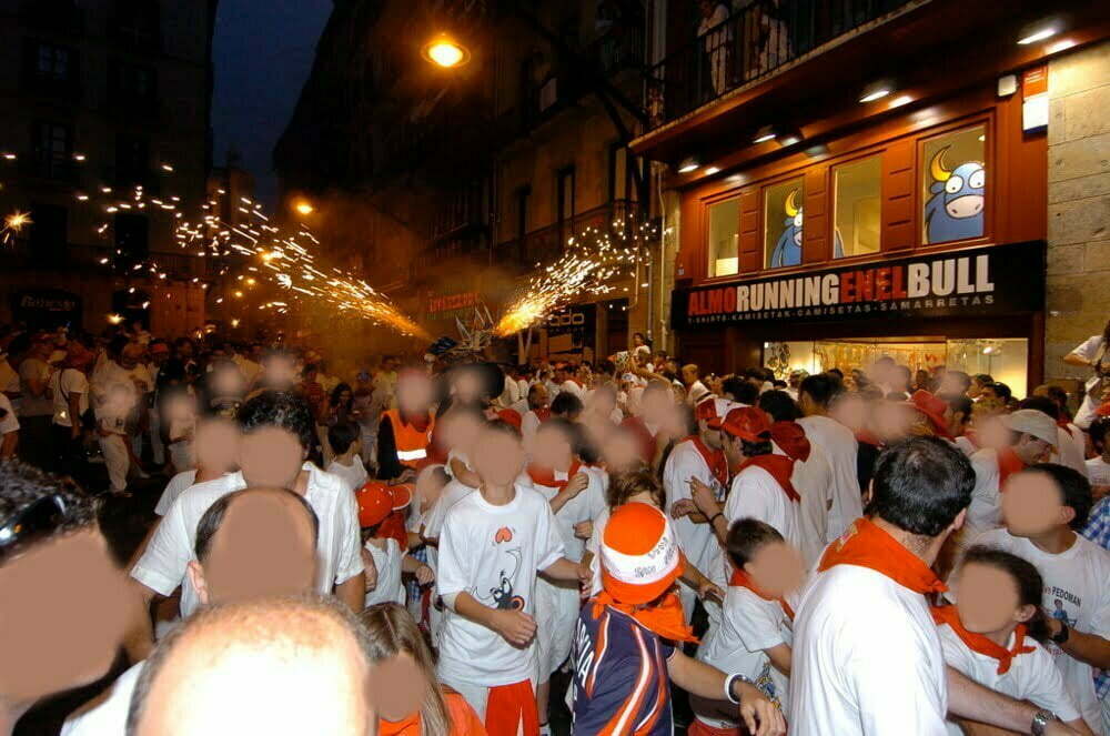
Fireworks

Every night at 23.00 and for about half an hour, the best European pyrotechnic houses offer a spectacular performance of fireworks from the moats of the walls of the Ciudadela, challenging each other in an international competition.

The best place to see it is the park near the bus station that surrounds the Vuelta del Castillo area, but it can still be seen from different points of the city, such as the streets adjacent to Avenida del Esercito, Plaza de los Fueros, Paseo de Sarasate and Plaza de la Paz.

Music

The newspaper “El Eco de Navarra” proposed that a marching band walk the streets of the city an hour before the encierro to wake everyone up, and the municipality accepted the idea.
At dawn on July 7, 1876, the band of the Casa de la Misericordia paraded playing the first dianas sanfermineras.

Since then the streets of the city are animated by multiple bands and the feast of San Fermín would be unthinkable without the music that animates it.

At every moment of the holidays, music invades the streets of the city, becoming itself an attraction.
The official schedule contains an endless supply of concerts and parties for all styles, in different areas of the city.

Traditional Basque songs blend with international ballads, classical music, rhythms of musical bands, disco music from pubs, bagpipes, outdoor concerts of pop, jazz, rock, traditional dances interspersed with salsa or merengue, modernity and folklore, seriousness and unbridled madness.

Essential is the music of the various peñas, which cross the streets of the historic center with drums, trumpets, trombones, whistles, bass drum, cymbals, saxophones, singing cheerful and catchy songs that quickly become popular for all those present.
Alternating in walking the streets of the city, they create an endless revelry every moment of the party.

Inside the arena, on the other hand, they play each on their own and the result is therefore confusing and dispersive.


Euskal Herria - Iruña/Pamplona - San Fermin


The Chupinazo: the start of the festival

The San Fermín festival starts at 12 noon on 6 July.
I don’t think I need to tell you that this is something you should try at least once in your life. But please don’t expect the Chupinazo to be like going to the theatre or cinema.
I suggest getting to the city nice and early so you can drop your backpack off at the luggage storage and then get a feel for the festival atmosphere.
The Plaza del Ayuntamiento starts to fill up, but just after 11:00 a.m., the Civil Guard moves everyone to the surrounding streets.
After a few dozen minutes, you can finally access the square to wait for the Chupinazo.
As the minutes go by, the square fills up, the pushing gets more intense and you quickly find yourself drenched in wine and sangria, literally from head to toe.
Even if you don’t mean to, the crowds can be overwhelming for people who are anxious, so it’s probably best to stick to the edge of the square or stand against the wall opposite the city hall.
The atmosphere is amazing: thousands of people all dressed alike, with red scarves and ribbons, and white clothes that begin to turn purple from the wine, enjoying themselves drinking, dancing and singing in a historic area that’s also full of the political messages that are typical of the Basque Country: the independence of Euskal Herria, support for political prisoners, chants for the home team Osasuna and, very strongly in recent years, solidarity with the Palestinian people.

It’s really difficult to handle the pressure of hundreds of people I thought I’d avoid the open space in the centre of the square, but I ended up being squashed against the wall or shop shutters on the sides.
A few minutes before noon, everyone raises their red handkerchief and sings.
The people picked for the ritual (usually local politicians but also Osasuna players) appear on the balcony of the town hall and the phrase is said: “Pamploneses, Pamplonesas, Irundarrak. ¡Viva san Fermín! Gora san Fermin!”.
At 12 p.m. sharp, the rocket is lit, kicking off the festival.
The city erupts with joy and the madness officially begins.

El Pobre de mí: the end of the festival

On July 14, where it all began on July 6, in front of the cityh at midnight, the mayor announces the end of the festival, giving appointment to the next year.
A flood of lit candles and red handkerchiefs move wistfully singing the song that gives its name to this last act: “Pobre de mí, pobre de mi, que se han acabao las fiestas de San Fermín” (poor me, poor me, the festivities of San Fermín are over).

The “Pobre de mí” is the other side of the Chupinazo: the darkness after the light, the sadness after the joy, but also the fatigue accumulated after days of crazy fun.
From this moment people have to return to everyday life. Many people will continue their party for a few more hours, before taking off the red handkerchief.

THE ORIGIN OF CLOTHING

Usually we know that the dress doesn’t make the monk, but sometimes the party makes the dress.
Traditionally in the Pamplona festival we dress in white (t-shirt, shirt, trousers or skirt) and red (waistband and handkerchief around the neck).
Obviously it’s not an obligation and everyone dresses as he wants, but dressing differently would make fish out of water, since almost everyone wears this “uniform”.
The advice is therefore to dress like this and immerse yourself totally in the tradition (obviously many shops and stalls sell the uniform at acceptable prices).

It’s not known exactly why nor who adopted this clothing, however, is now an integral symbol of the party. Everyone wears it creating white and red human tides.

There are, however, various theories about this popular custom.

Some indicate as inventors the members of Peña la Veleta.
Founded in 1931 by people of humble origins and of the working class, they sought a uniform that would identify and distinguish them from other associations.
A white robe was easy to obtain, inexpensive and, associated with red, very flashy.

In any case, it becomes a common dress among the people who participate in the festivities around 1960.

In addition to the white dress, two other accessories are equally important:

The red handkerchief is knotted around the neck after the launch of the Chupinazo and is removed after the “Pobre de mí”.
Even on its meaning there is no univocal version: it goes from the blood of St. Fermín martyred, to the flag of Navarre.
Many handkerchiefs have embroidered the figure of San Fermín, others the coat of arms of the group to which they belong or the flag of Navarre, Pamplona or the Basque Country.

The band that surrounds the waist is also red. It usually ends with fringes on the sides and sometimes with embroidery such as handkerchief.

To complete the official uniform, tradition indicates white hemp sandals with red ribbons but comfort has now cleared the tennis shoes. However, you need to have closed and resistant shoes, both to avoid slipping and because you can find broken glass (and not only) in the streets.

When the air becomes cooler, you wear a red jacket.

USEFUL INFO

Rules

On festive days, Pamplona has a reputation for being a lawless city but this is not true.
From the arrival in the city the controls, even with anti-drug dogs, are very stringent and no overstep of the limit is tolerated.
The police actions are lightning fast.
However, this allows everyone, from young children to the elderly, to walk around alone without problems, at any time of day or night.

Even the encierro itself is regulated by a series of norms and customs imposed by the centuries-old tradition. In addition, there is a municipal ban of the City of Pamplona and a Navarrese law on bullfighting shows that, if broken, leads to heavy fines.
Among other things, it is prohibited:
– participate in the race to under 18,
– leave the doors of homes and business premises open,
– run under the effects of alcohol or drugs,
– use cameras or phones, footwear or clothing inappropriate for running, bulky objects that restrict movement or hinder other participants,
– grab, hit, incite bulls or attract their attention.
Help must be given so that the herd runs in the correct sense of the encierro and that the race lasts as little as possible.

Euskal Herria - Iruña/Pamplona - San Fermin - Encierro

Recommendations


San Fermin Pamplona - runners waiting

To participate in the encierro with some “guarantee” of success, you must to follow a series of recommendations dictated by the experience of the most veteran runners, those who have done dozens of bull runs:
– sleep before the run, even if only a few hours, and never run as the conclusion of a night of revelry,
– don’t wear moccasins, sandals, heeled shoes or slippers,
– use even more precaution with wet road: bulls slip, but you will do the same,
– don’t run without looking behind: in the encierro the risk is behind, not in front.
– don’t overestimate your physical fitness: the bulls run more than you, check them or they will overwhelm you,
– take the utmost precaution when leaving the road: most horns hit people who are stationary or fallen,
– in difficult moments, don’t try to climb the fence but lie on the ground and rotate to the sides,
– enter the route only if you are convinced to take part and really running: standing still on one side you would risk being seriously injured by bulls, runners, or creating danger for everyone,
– remember that you can die: the risk is very low but take into account that participating in the race you could die or be seriously injured.

Dangers


Euskal Herria - Iruña/Pamplona - San Fermin - Encierro

Pamplona’s bull run is known all over the world and there are two types of people who do it: those who arrive prepared and those who decide to do it at the last moment.

The goal is to start running slowly, then at full speed before the arrival of the bulls, stay in front of them more or less close depending on the desire to risk the life, and move away sharply from their trajectory, trying not to cross or endanger the other runners.

One of the main aspects of the encierro pamplonese is its intrinsic dangerousness: running with bulls implies a huge potential risk.
There are 14 boys who died, twelve due to horns, the others from blows or crushing.
11 of them were mortally wounded when they were stationary or fallen.
The deaths occurred on all sections of the race: 2 in Santo Domingo, 2 in the Plaza del Ayuntamiento, 1 in Mercaderes, 1 in Estafeta, 4 in Telefónica area and another 4 in the arena.

In addition to the dead, however, we must also consider the high number of wounded.
It’s estimated that 1 in 70 participants finishes the race with minor injuries such as bruises, erosions, sprains, etc.; 1 in every 800 is transferred to the hospital for severe trauma, 1 in every 2,500 is framed and 1 in every 100,000 dies.

How to get there


San Fermin Pamplona - station walls

Pamplona Airport has regular connections to Madrid and Barcelona.
Other nearby airports are Bilbao, San Sebastian, Zaragoza and Biarritz.

The train station is quite close to the center and has regular lines to all major cities.

The bus station is located at the Parque de la Ciudadela and also in this case the connections are numerous and frequent.

Those who decide to use the car, must consider above all the cost of parking. You must also pay in advance, otherwise you will add the fine and the recovery of the car taken away by the police.

Where to sleep

Pamplona multiplies its inhabitants in these days of July and the housing is filling up quickly.
Beyond the date of booking, the costs of hotels and b&b on holidays reach very high price: it will be difficult to spend less than € 200,00 per night per person.
A bed in a shared dorm in the hostel costs just under half.

San Fermin Pamplona - balconies

Similar prices are also in nearby towns 30 km, to which must be added, however, the cost of travel.

If you want to save money, you can sleep almost anywhere.
It’s not forbidden to sleep in the street or in the gardens but you can’t camp. You have to be equipped for the night: temperatures can reach 15°C with a considerable temperature change, and it can rain.

San Fermin Pamplona - where to sleep


Left luggage

If you don’t have accommodation, it’s better for safety and convenience to leave your luggage in a storage room.
There are two public places to leave your luggage (in 2022 only one):
– Escuela Municipale San Francisco (closed in 2022): open 24 hours a day from 4 to 16 July, it’s located in the center and, in addition to luggage storage, it’s also a multilingual tourist information center and has dressing rooms for changing.

The cost is € 4,50 every 24 hours, they will ask for a copy of your id card and leave a ticket to be returned to retrieve the luggage.

– Bus station: on the lower floor, in the square where the buses leave, there is both a served luggage storage and some automatic lockers.
The cost is always € 4,50 but from 6 a.m. to 10 p.m..
At other times the bus station is closed and inaccessible.

What to eat


Euskal Herria - Iruña/Pamplona - San Fermin

Spending time drinking and eating traditional Basque dishes or different types of pintxos, sharing the table with strangers, is a substantial part of the party.
In Navarre, any social event includes a gastronomic moment as an indispensable part of the celebration.

You have an endless amount of places to eat, enjoy trying different food.

Lost property

The lost property office is inside the municipal police station.
If you find something you can take it there or deliver it to the many agents or volunteers always present around.

Showers

The organization of the feast of San Fermin certainly could not neglect the shower.
In addition to the public baths, there is also the place to wash: the Casa de Baños y lavandería Pública, in calle Hilarión Eslava 9.

With 4 euros (in 2022, prices change every year) you have a single dressing room with shower, towel, shampoo and shower gel.

Some people use to go to the Piscinas de Aranzadi, the public swimming pool near the Casco Viejo.

NAZCA LINES: HISTORY AND MYSTERIES

WHAT ARE THE NAZCA LINES?

The Nazca Lines are still one of the greatest archaeological mysteries to decipher.
In an arid coastal plain of Peru, near the city of Nazca and about 450 km south of the capital Lima, there are a lot of geoglyphs (drawings traced in the ground) depicting animals (whale, monkey, dog, flamingo, spider, condor, lizard, frigate bird, parrot and others), plants, geometric figures and various drawings, extending for several kilometres.


Peru - Nazca Lines map


The lines, 40 to 210 centimeters wide and up to 30 centimeters deep, are perfectly straight even if they cross hills, rough terrain and depressions.
They were traced simply by moving the stones made dark by oxidation from the ground, so that the underlying gravel highlighted the figures with its pale yellow and reddish-brown color.

All the drawings are made with a single continuous line, without interruptions.


Peru - Nazca Lines close up


Their shape is understandable only from above and this increases the mystery of how and why they were created.

The climate of the Nazca plateau, characterized by stable temperatures at 77°F and rains practically non-existent, would have safeguarded the figures to this day.

Since 1994 they have been recognized as a UNESCO World Heritage Site.

DISCOVERY OF THE NAZCA LINES

The first evidence of the existence of the Nazca Lines dates back to 1547, when the Spaniard Pedro Cieza de Leon spoke of “signs in some areas of the Nazca Desert”.
However, these claims were not investigated at the time and were soon forgotten.

Even if some shapes are visible from the nearby hills, it was pilots of the Peruvian Air Force who reported their presence, after almost four centuries.


Peru - Nazca - agricultural land


In 1929, Peruvian archaeologist Julio Cesar Tello began studying them, describing them as “sacred roads”.
In the same year, American anthropologist Paul Kosok did the same with his partner, the German Maria Reiche Neumann. Their interpretation pointed to a giant solar and lunar calendar with which Nazca astronomers made predictions about harvest and rain.
Maria Reiche Neumann has dedicated her whole life to carrying out research, preserving it and making it known to the world.
Thanks to her work, the Nazca Lines were declared a World Heritage Site by UNESCO in 1994.

WHO DREW THE NAZCA LINES?

Tests with Carbon 14 proved unsuitable for certain dating so the drawings in the plateau were compared with ceramics found in Cahuachi.
Some scientists believe that the drawings were made by the Nazca civilization in different periods, from 300 BC to the 15th century BC, when the Mesoamerican peoples were progressively destroyed by the Spanish conquerors.

It’s possible that they made small-scale drawings and then reproduced them on the ground, multiplying the measurements with a network of poles and ropes.
Taking in mind that at ground level it’s not possible to perceive whether the figures are drawn correctly or not, it is thought that the construction was organized from an elevated place.
A place that may have been a hill, but some scientists proved that the Nazcas had the knowledge to get a hot air balloon up.


Nazca Lines drawn from the hills?


WHAT DO NAZCA LINES REPRESENT?

As unfortunately often happens, what we cannot immediately understand we think cannot have a logical explanation.
It seems impossible that civilizations lived before us had much more advanced scientific and engineering knowledge than ours, to the point that we still cannot understand how they were able to build certain constructions or know the cosmos better than we do.

Since the mystery is far from being solved, the hypotheses are a lot. Let’s see some of them.


Peru - Nazca lines - Whale from the plane

Peru – Nazca Lines – Whale from the plane


Peru - Nazca Lines - Whale zoom + highlighted image

Peru – Nazca Lines – Whale zoom + highlighted image


Religious hypothesis

A Spanish document from 1653 explained that in the Inca capital of Cusco the sanctuaries were built along lines that started from the Temple of the Sun.
The Aymarà tribe, who lived near Lake Titicaca, also drew very similar lines to join small stone buildings used for sacred functions.

Similarly, some scientists consider the Nazca Lines to be paths used for religious purposes.
In fact, the drawings have one entrance and one exit line, after having covered the whole figure.
It is therefore easy to imagine crossing it in an single file, as during a procession.
In the vicinity of some of the larger figures were found pieces of ceramic vases, agricultural products and marine animals.

Others assume that the drawings were drawn to be seen by their gods, who obviously lived in the sky.


Peru - Nazca Lines - Humming Bird from the plane

Peru – Nazca lines – Hummingbird from the plane


Peru - Nazca Lines - Humming Bird zoom + highlighted image

Peru – Nazca Lines – Hummingbird zoom + highlighted image


Astronomical hypothesis

Ancient civilizations have demonstrated much more precise and advanced astronomical knowledge than ours.
It is therefore logical that a hypothesis sees a link with astronomical observations.
Some figures have identical orientations to the Pleiades and other constellations while some have intersection points with sunrises or sunsets at certain times of the year.

The Nazca Lines could be a huge astronomical calendar, with figures representing constellations and lines indicating the celestial course of certain stars.

Those who want to dismantle this thesis argue that not all drawings have an identical positioning in the celestial sphere, so the mystery cannot be solved, at least exclusively, with an astronomical calendar.


Peru - Nazca Lines - Spider from the plane

Peru – Nazca lines – Spider from the plane


Peru - Nazca Lines - Spider zoom + highlighted image

Peru – Nazca Lines – Spider zoom + highlighted image


Geological hypothesis

Some researchers see the Nazca Lines as a sacred place where rituals were made for rain and the vital search for water.
For several morphological reasons, water coming down from nearby mountains was absorbed by the desert but continued to flow underground.
The Nazca civilization was able to create sophisticated and ingenious aqueducts, connected by pipelines, from which they extracted water from the aquifers and rivers at a depth of tens of meters.


Peru - Nazca - cultivated areas and desert

Peru – Nazca – cultivated areas and desert


In this way they made very arid lands arable.
Even today you can see large green oases with small pastures and crops of cotton, beans and potatoes.

According to this hypothesis, drawings of the Nazca Lines indicate the placement of fountains, wells, springs, aqueducts, etc.

Artistic hypothesis

However, the Nazca Lines can be considered the greatest graphic work on the Earth.
The drawings are fascinating and geometrically perfect, so one hypothesis assumes that this is a giant art gallery, designed to be observed from above.
And if this is true, one would have to admit that over 2000 years ago man already knew how to fly.


Peru - Nazca Lines - Parrot from the plane

Peru – Nazca lines – Parrot from the plane


Peru - Nazca Lines - Parrot zoom + highlighted image

Peru – Nazca Lines – Parrot zoom + highlighted image


In 2015, a team of researchers from Japan’s Yamagata University presented the theory that geoglyphs have been tracked by at least two cultures and that their purpose has changed over time.
Born to religious worship, they were later made to adorn the pilgrimage route to the pre-Inca city of Cahuachi, capital of Nazca culture.

Extraterrestrial hypothesis

Since one of the figures is called “the astronaut” because its similarity with the appearance we give to extraterrestrial beings, there can of course be no lack of hypotheses on this subject.
The very long lines and gigantic drawings of animal would be a reminder for “prehistoric extraterrestrials”.
Some perfect lines are more than 8 km long and one in even 65 km long.
They could be a landing strip for UFOs.
Or it could be the extraterrestrials who drew the drawings, visible only from above.


Peru - Nazca Lines - Astronaut from the plane

Peru – Nazca lines – Astronaut from the plane


Peru - Nazca lines - astronaut zoom + highlighted image

Peru – Nazca lines – Astronaut zoom + highlighted image


A similar but in some ways even more shocking theory arises from the textiles used by the Nazca.
The filaments were narrower than those used centuries later to build airships and did not even allow water to penetrate.
This does not mean that they knew how to fly balloons or airships, but that they had the tools to do so.

Dinosaur hypotheses

In 1961, not far from here, the River Ica flooded the surrounding village with the same name, bringing to light thousands of decorated stones.
Their existence was already known at least 500 years before, since a chronicler of the time described them as a trousseau of the Inca nobles.
In May 1965, farmer Felix Llosa Romero donated one of these stones to his friend Javier Cabrera Darquea, a surgeon at the Ica Hospital and professor of biology and anthropology at the University of Ica.
In that stone, however, was engraved an agnathus, a fish extinct thousands of years before and certainly unknown to Peruvian farmers.
Cabrera then began to buy all the similar stones, going so far as to have about 15,000 that he decided to exhibit at his own expense in the House of Culture of Ica.


Peru – Ica Stones – Dinosaurs

Peru – Ica Stones – Dinosaurs


The stones are made of granite andesite, the dimensions range from a few centimeters to about one meter and were engraved before oxidation, believed to have occurred around 12,000 BC.
This would mean that those civilizations had incredible technological knowledge.

But even more shocking are the themes of the drawings depicted: dinosaurs and extinct animals, astronomy, maps of ancient continents, cataclysms, medicine and surgical operations.
In short, the drawings on the stones of Ica show very advanced knowledge that a primitive civilization (in our opinion) should not have, and figures of animals extinct millennia before the supposed birth of man.
They also represent interactions between humans and dinosaurs with attitudes similar to those we have with our pets today.


Peru - Ica Stones - Man on triceratop

Peru – Ica Stones – Man on triceratop


If we don’t want to admit that humans and dinosaurs lived together, we have to accept that 12,000 years ago our ancestors found and studied dinosaur fossils.

What is the connection of the Ica stones with the Nazca Lines?
Among the various drawings are some where men ride pterodactyli, observing a stegosaurus with a telescope.
What if the Nazca Lines were observed in this way?

Of course, this thesis is dismantled mainly in two ways.
Most scientists need only the reference to “Darwin’s theory of evolution” and the consequent impossibility of coexistence between dinosaurs (said to be extinct 65 million years ago) and the first hominids (Australopithecus appeared about 4 million years ago and Homo Habilis about 2.5 million years ago).

Others consider the Ica stones a hoax created by Peruvian farmers.
The quality of the designs and the style of the carvings obviously improves in the stones discovered in more recent times.
No doubt the hype has prompted many forgers to decorate some stones to sell them to tourists as souvenirs, but they should also be distinguished from those mentioned 500 years ago…

Sports hypothesis

In 1980 some researchers carried on the idea that the Nazca plateau was a great sports arena, where “Olympic Games” were organized.
The lines would then be circuits where the competitions took place.


Peru - Nazca Lines - Frigate from the plane

Peru – Nazca lines – Frigate Bird from the plane


Peru - Nazca Lines - Frigate zoom + highlighted image

Peru – Nazca Lines – Frigate Bird zoom + highlighted image


HOW TO SEE THE NAZCA LINES

Before departure

The best way to get your own idea is always to see for yourself what you’re talking about.
To see the Nazca Lines you have to arrive in the homonymous Peruvian town.
Cruz del Sur buses connect Nazca with Lima, Paracas, Arequipa, Cusco and Puno.


Peru, Nazca

Peru, Nazca city


But as I said, the only way to see the drawings is from above.
The essential stop is therefore the Nazca Airport, from where the small planes flying over the desert daily.

Almost two months in advance, after reading so many reviews, I booked the fly with Aeroparacas company.


Peru - Nazca Lines - AeroParacas


Arriving at their offices on the chosen day, there was no trace of our conversations but I still pay 90 euros for a flight that would take off after about two hours.
In the small airport your passport is checked and you are weighed. This passage is essential because you will fly on small Cessna and the plane must be balanced.
Aeroparacas’ seriousness with me has been non-existent.
Despite having paid in advance, I was put on the waiting list, warned several times that maybe the airport was going to close due to the sandstorms, only to be boarded shortly after making a memorable outburst.
After 6 hours of patient waiting.

The flight

My advice is therefore to go to the airport early in the morning by yourself and ask at the check-in desks of all the companies for the nearest departure time and the best price.
The cost is about 80 euros to see 12 figures in 30 minutes of flight, or 150 euros for 20 figures in 60 minutes.
Much higher prices are not justified.

As said, the planes are Cessna with 7 seats: the pilot, the co-pilot (who will explain each figure to recognize it quickly, following the tip of the wing) and 5 passengers (two in the first row, two in the second row and one in the queue).


Peru - Nazca Lines - AeroParacas interior aircraft

Peru – Nazca Lines – into the AeroParacas airplane


Everyone has headphones to listen to the co-pilot and a map showing the plane’s route and the location of each geoglyph.
The figures are not always immediately distinguishable and it will take concentration and imagination to recognize them in the midst of many lines that ply the ground. And you need also a great eye view.

ou have to be aware that the flight will not be quiet but the plane will constantly tilt first to one side and then to the other, to allow everyone to see the famous Nazca Lines.
Or rather, to allow it to those who do not suffer from the plane and can see well.


Peru - Nazca Lines - Monkey from the plane

Peru – Nazca Lines – Monkey from the plane


Peru - Nazca Lines - Monkey zoom + highlighted area

Peru – Nazca Lines – Monkey zoom + highlighted area


If you know that you’re afraid to fly, that you can’t handle the inclinations of the plane, if you suffer from vertigo or if you don’t see well from a distance… Forget it.
And, in any case, avoid having breakfast before your flight.
You would spend at least 90 euros not to distinguish any drawings or, worse, to spend the whole flight vomiting while, with your eyes closed by fear, you pray to come back to the ground alive.

I sat in the back of the plane and that allowed me to see both the left and the right sides.
I filmed the entire flight and only on landing did I realize that the other 4 passengers had experienced the worst flight of their lives, or maybe the worst nightmare ever.


Peru - Nazca Lines - plane route on figures


MY CONCLUSIONS

The uniqueness and mysteries of the Nazca Lines make this place a destination to visit to reflect on what you see.
They have fascinated me more than Machu Picchu, but that doesn’t mean I was excited.
On the contrary, they left me with a lot of doubts and perplexities.

Obviously I’m not a scientist, historian, geologist etc but I travel to see the world with my own eyes, analyze and make my ideas.


Peru - Nazca Lines - Flower from the plane

Peru – Nazca lines – Flower from the plane


Peru - Nazca Lines - Flower zoom + highlighted image

Peru – Nazca Lines – Flower zoom + highlighted image


The first thing I thought as soon as I got off the plane was “it’s not possible that these drawings have been there since 2500 years, where planes can’t fly because wind and sandstorms.”
There are lines 40 centimeters wide and 30 centimeters deep: it’s not possible that in 2500 years rain and wind have not buried them or that someone has not unkkedly ruined them or by vandalism.
It is true that some figures have now been almost completely erased by the construction of the Panamerican or by tyre tracks.
Some drawings also seemed to me too “futuristic” to have been made 2500 years ago.

Believing that the climate that has remained unchanged for millennia has protected the drawings, my idea is that they were made by different civilizations and in very different times.
I think that the first lines were made for religious reasons: the gods were invoked (maybe each figure represented a different deity) and processions were made along the lines in single line.


Peru - Nazca Lines - Flamingo Heron Alcatraz from the plane

Peru – Nazca Lines – Flamingo Heron Alcatraz from the plane


Peru - Nazca Lines - Heron Flamingo Alcatraz zoom + highlighted image

Peru – Nazca Lines – Flamingo Heron Alcatraz zoom + highlighted image


I have no doubt that some ancient civilizations had much more advanced knowledge and specialization than our current ones.
That’s why I’m sure that they wouldn’t have had difficulty in drawing complex and mile-long figures using poles and ropes.
But above all I do not deny that they could have had the ability to look at them from above with flying objects similar to hot-air balloons or airships.
The truthfulness of the Ica stones and the consequent thesis of coexistence, moreover friendly, between humans and dinosaurs is fascinating but perhaps more difficult to support than the previous one.


Peru - Ica Stones - T Rex

Peru – Ica Stones – T Rex


Ancient civilizations (Maya, Aztecs, Egyptians, Shardana, Babylonians, Persians, etc.) had much more advanced astronomical knowledge than ours. This was seen both from the calendars and in their constructions linked to celestial events at particular periods of the year (not only sunrises and sunsets but equinoxes, solstices, eclipses…).
This obviously makes me think that some drawings depict constellations, celestial routes or otherwise cosmic events.
In part, the Nazca Lines are an astronomical calendar.

I also support the artistic hypothesis, which is also divided into at least two historical periods.
One is related to the period when pilgrimages were made to the capital Cahuachi.
They could have been signs, prayers or, why not murals by the “young Nazca vandals writers”.


Peru - Nazca Lines - Tree Lizard Hands from the plane

Peru – Nazca lines – Tree Lizard Hands from the plane


Peru - Nazca Lines - Hand Tree Lizard Zoom + highlighted image

Peru – Nazca Lines – Tree Lizard Hand zoom + highlighted image

The second historical period, or at least the last, in my opinion dates back to the present day.
Some forms are too futuristic, almost identical to characters from movies, comics or cartoons.
Maybe I’m too skeptical, but these were in my opinion made to “increase the myth” and create new sources of investment and profit.

What would the city of Nazca be if the Lines weren’t there?
Would there be a flow of tourists, travelers, curious, scientists, ufologists etc if there were no Lines?
Would there be airlines, hotels and all the economic income if the Lines weren’t there?

What do you think? What idea have you had about the Nazca Lines?
Leave a comment.


Peru - Nazca Lines - Condor from the plane

Peru – Nazca lines – Condor from the plane


Peru - Nazca Lines - Condor zoom + highlighted image

Peru – Nazca Lines – Condor zoom + highlighted image


THE IMPORTANCE OF EXPERIENCES

Ognuno di noi è frutto delle proprie esperienze e questo è ancora più vero se sei un viaggiatore o una viaggiatrice che gira il mondo per entrare in contatto con popolazioni, culture e tradizioni molto diverse da quelle in cui sei nato.
By travelling with open eyes, mind and heart, we can only learn and improve.
In this case, however, I speak of experiences because visiting a lot of places around the world, we have also several parameters of comparison.

cosmorevas travel map 2025-09-21

Visiting one place before another influences our perception of beauty and wonder.
Perhaps one should build up gradually, but that is not always possible.
We can’t say that one place is better than another without having seen it.

Another parameter of comparison (for me and many others, maybe not for everyone) is the amount you spend.
Some people with whom I spoke went to Machu Picchu on their honeymoon.
This is a decisive factor: is different if you have a fully paid trip or have to pay as little as possible and what you considered “the correct price”.

BEAUTIFUL BUT…

This anticipation was necessary to understand why for me is difficult to talk about Machu Picchu, the place that left me with the most deep sense of disappointment.

Maybe I should try to think objectively, imagining that I went to Machu Picchu without spending anything and without having seen other wonders of the world (official or subjectively considered as such).
But the web is already full of similar stories.
I only tell what I saw and the emotions I felt. Neither right nor wrong but real and sincere.

My past experiences weigh heavily on the considerations I am about to make.
Peru wasn’t my first trip, and because I’d already seen the Mayan cities (Palenque and Yaxchilan), the Aztec city of Teotihuacan and the Temples of Angkor, Machu Picchu didn’t impress me too much.

Beautiful but… I’ve been to… here instead…


statues and sign Welcome to Machu Picchu - village of Aguas Calientes - Peru


Another thing that made me think negatively about Machu Picchu (and I’m not talking about the site itself, but the surrounding area) was the crazy amount of money you have to pay.
I often thought about whether I’d made a mistake, but I don’t think I could have saved much, and it would have been really tiring (I could have done it, but I also had to think about the fact that this was the last part of my month-long trip to Chile, Argentina, Bolivia and Peru, with a temperature difference of 70°C and an altitude difference of about 6,000 metres).

I’ll fill you in on the details in a sec, but I can already tell you that going to Machu Picchu costs about £450 on average.

Nice but… here I paid… there instead…


HISTORY

Machu Picchu, Machu Pikchu in the native Quechua language, “old mountain” is a 3,082-metre-high mountain on which the Incas built their city.
Over time, the name has also been associated with the archaeological site.
A World Heritage Site and one of the seven wonders of the modern world, it is famous worldwide for its spectacular location, nestled among the peaks of the Urubamba River valley.


Peru - landscape of Machu Picchu from the archaeological site


The city, or perhaps only the summer residence of the emperor and the Inca nobility, should have been built around the year 1440 and inhabited until the Spanish conquest in 1532 by a permanent population of about 300 people, with a peak of 1,000 when the emperor went.
It was never really abandoned or forgotten, but some locals went and live there, making use of the agricultural terraces and complex water channels.

On 24 July 1911, the American historian Hiram Bingham reached the peak of the mountain and was pretty impressed by what he saw.


Peru - landscape from the top of Machu Picchu Mountain

He quickly realised how important these ruins were in history, so he did some digging and put out a few publications around the world. He got some support from the Peruvian government, Yale University and National Geographic for this.


Machu Picchu has becomel Peru’s main tourist destination in just a few years.


HOW TO GET

Cusco

The first stop is to arrive in the city of Cusco.
There are at least two ways, depending on the departure and the time available.
Cusco airport is connected to the capital, Lima, with lots of daily flights, and they’re pretty cheap too.
This could be the best option if you’re arriving in Lima on an international flight (from Europe or, usually, from Mexico City, Santiago de Chile, Bogotà or Buenos Aires).

Otherwise you can get to Cusco by bus. I’d say this is a good option if you’re arriving from the south, maybe from Nasca o Arequipa) or if you’re coming from Bolivia (maybe after a one-day stop in Puno to check out the floating villages on Lake Titicaca).
The best quality/price solution should be the Cruz del Sur company.


Peru - bus Cruz del Sur


I used it for some trips and the buses are very clean and immaculate.
The seats on the 1st floor (semi-cama), allow you to sleep peacefully even if the seats do not recline very far.

Thinking about the comfort of reclining the seat 170°, I chose the ticket for the upper floor.
But, like everything else, respect is always needed.
It’s nice stay almost like in a bed, but it means that the person behind will not be able to move because the front seat will rest on his/her knees.
I spent an entire 13-hour journey fighting with the “enemy” of the seat in front of me: he would slam the seat on my knees to tilt it to the maximum and I stopped him with punches and kicks in the backrest and headrest.
Imagine how relaxing this trip was…


From Cusco to Aguas Calientes

Once you arrive in Cusco, you need to find a way to get to Aguas Calientes, the small village that seems to have been created solely to exploit the tourists who go to Machu Picchu.

To make it simple, there are 4 solutions:

1. Gipsy mode: colectivos (shared vans, the classic means of transport throughout South America) depart from Cusco square for Hidroelectrica. The cost of this trip is about USD 10.
From Hidroelectica you walk for about 30 km until the village of Aguas Calientes.


Peru - Sacred Inca Valley seen from the train Perurail Cusco Ollantaytambo Aguas Calientes Machu Picchu


2. Perurail Train: the easiest option, and therefore obviously the most expensive, is the direct connection, travelling through the landscapes of the Sacred Valley of the Incas.
The trains have large panoramic windows, comfortable seats and offer a complimentary snack and drink.
A few months before departure, it seemed impossible to me that a return ticket would cost almost €180, so I decided to give up, convinced that I would find a better solution in Cusco.
Instead, the price there had risen to around 300 euros.


Peru - Perurail train to Machu Picchu at Ollantaytambo station


3. Middle way: I didn’t want to pay it USD 300 but I was also too tired to think of doing 60 km with my backpack, so I chose the classic “middle way”.
I took a colectivos from Cusco to the intermediate railway station of Ollantaytambo, and from there the Perurail train to Aguas Calientes. I booked a last minute ticket for about USD 110 one way.

4. Inca Trail: considered one of the most beautiful treks in the world, it usually takes 4 or 5 days.
Tickets are limited to 500 people, of which about 300 are local guides (required).
The old 43 km long mountain trail links the Inca archaeological sites of Runcuracay, Sayacmarca, Phuyupatamarca, Winay Wayna and Machu Picchu.
Prices range from USD 650 to USD 1,500 depending on the duration and comfort required.


Peru - cosmorevas Inca Trail Machu Picchu map


SITE ENTRANCE TICKET

The Government of Peru often varies the conditions and times of access (it has tried to impose stricter time slots and shorter stay times)
I do try to keep this info up to date, but it’s best to check it when you need to.

The official website to buy tickets directly is www.machupicchu.gob.pe.
Choose with the most attention the date and time of entry because access is very fiscal and punctual.
Theoretically the stay at the site is not infinite but the times are limited in according to the ticket bought.
No one will look to throw you out, but if you are at fault (but do it anyway) avoid to attract the attention of the guardians for incorrect or forbidden behaviour acts.
For example, even if I consider them absurd and shameful, it’s forbidden to enter with backpacks or bags larger than 40x35x20 cm, bring food or drinks that have not been purchased on the site and have trekking sticks, umbrellas, camera tripods or smartphone holders.

There are 3 types of ticket:
– Machu Picchu: 2.300 places per day, entrance limited to the Inca city, cost about USD 60.
Places are limited to 800 accesses from 6am to 9am, 600 from 9am to 12, 360 from 12am to 1pm and 540 from 1pm to 2pm.
Theoretically you can stay in the site 4 hours from the moment of entry but there are not checks about it.

– Machu Picchu + Mountain: 400 places per day, including a visit to the Inca city and trekking on Machu Picchu Mountain, cost about USD 80 (discounts for children, students and citizens of Peru, Bolivia, Colombia and Ecuador).
There are 3 times available: 100 places to enter Machu Picchu from 06am and start trekking on the Mountain from 07am to 08am, 100 places to enter the Mountain at the same time but in the city only after the trekking, and the last 200 tickets to enter Machu Picchu from 08am and the Mountain from 09am to 10am
You could stay on the site for a maximum of 8 hours, while the return from the Mountain must take place before 1pm.
I chose to book this ticket as “the middle way”: entering only the archaeological site seemed reductive to me, the Inca Trail was instead excessive and this mountain is higher than Huayna Picchu and therefore more panoramic.

The climb to Machu Picchu Mountain was very hard and tiring.
I had read that it takes 2-4 hours to reach the top and go down.
I tell that after more than 2 hours of climb on the steep path, among irregular dirt tracks and narrow steps, in the middle of the jungle and with the fauna represented mainly by mosquitoes and gnats, I decided to stop and come down.
This is also because, beyond the physical and mental effort, climbing the mountain was very boring.
Man mano che si sale, il paesaggio è sempre lo stesso, solo che lo vedi da una maggiore altezza.
As you climb the landscape is always the same, only seen from a greater height. I would have climbed to the top to see a totally different landscape, but to see the same I’ve not found a good reason.

It is obviously a subjective thought but, while relaxing on the stairs, I talked with other “climbers”.
No one found the right spark to convince others, and above all themselves, to climb to the top.
We all started off excited but, who first and who later, we gave up, evaluating the excessive effort compared to the achievable result.


Peru - stairs to Machu Picchu Mountain


– Machu Picchu + Huayna Picchu: 400 places per day, including a visit to the Inca city and trekking on the Machu Picchu Mountain, cost about USD 80.
There are 3 times available: 100 places to enter Machu Picchu from 06am and start the trek from 07am to 08am, 100 places to enter the same time in Huayna Picchu but in the city only after the trek, and last 200 tickets to enter Machu Picchu from 08am and Huayna Picchu from 10am to 11am.
You could stay a total of 6 hours but the excursion to Huayna Picchu takes about 3 hours.

Huayna Picchu is the “young mountain”, 2693 meters high, famous for appearing behind the archaeological site in classic panoramic photos.
The ascent takes place on a narrow, steep, zigzag path, with sections where the stairs are directly carved into the rock.
This trek is not recommended for those who suffer from vertigo because its precipices and access is only allowed to +12 years.
You should reach the top in about 1 hour, but I haven’t climbed it so cannot confirm this information.


Peru - landscape of Huayna Picchu Mountain and the Andes Mountain from Machu Picchu Mountain


THE ARCHAEOLOGICAL SITE

Let’s take a closer look at the archaeological site of Machu Picchu.
The royal Inca city of Machu Picchu is located in the Andes Mountains, between the prominent peaks of Machu Picchu and Huayna Picchu, on a high mountain ridge with steep precipices as far as the Urubamba River and near the springs of the Amazon River
It’s also located in a highly seismic region, constantly affected by strong earthquakes and subject to heavy rainfall throughout the year.

Despite this, the city is still intact, demonstrating the high technical and scientific knowledge of the Inca civilization, which hadn’t written language and didn’t know the wheel or the iron.

The complex is divided into two large areas: the urban area and the agricultural area, separated by large squares.
The site is, however, largely to be deciphered, the names and functions of the structures are hypothetical and still under investigation.

Peru - landscape of Machu Picchu Square and Huayna Picchu Mountain with Andes Mountain

The urban area

Houses were built here and civil and religious activities were also done.
The Temple of the Sun is one of the best examples of organic Inca architecture and the only circular building in Machu Picchu.
In the lower part there are symbols and steps, inside a sculpture and niches used for ceremonial purposes related to the cult of the dead.
In the upper part, a large sculpted rock served as an altar while the windows were used for observing astronomical events.
For a Sardinian it’s immediate to associate it, both in shape and use, with a nuraghe.

Under the Temple of the Sun, almost hidden, there is a natural stone cave known as the royal tomb.
Some scientists suppose that it was the mausoleum of the Inca emperor Pachacutec.


Peru - Machu Picchu - Temple of the Sun


The capanna del custode is one of the few renovated buildings.
Its high thatched roof is the most accepted hypothesis of how the original roofs of the houses were.


Peru - caretaker's hut Machu Picchu


The agricultural area

The secret of its longevity is the drainage system.
The urban area has 129 canals that prevent landslides and erosion, canalising all the water to the agricultural area of the city and to the spring area, providing a perennial spring of water.
Here the foundations of the agricultural terraces have been built with stone retaining walls, a thick layer of surface soil and, deep down, larger stones, gravel and chiselled stone shavings.


Peru - agricultural terraces Machu Picchu


This perfect engineering work ensured the necessary drainage to prevent rainwater stagnation and erosion of the hills.
There was no irrigation system on the terraces because the Incas considered rain to be sufficient for this purpose.


Peru - Machu Picchu - into the city


EXPENSES SUMMARY

In this computation I prefer to omit the costs, too variable and subjective, to arrive from any place in the world to the city of Cusco.
So I focus on how to reach Machu Picchu from Cusco.

Cusco: the city certainly deserves a few days dedicated but, beyond that, it’s better to sleep here after visiting the archaeological site
You could still stay in Aguas Calientes but, as said, there the costs are much higher while in Cusco you can find a bed for USD 5.

Train: the price varies depending on the travel period, the booking date (I booked the last day in Cusco because I didn’t think that the prices seen online were real) and the departure station.
In general you have to pay about USD 150 from Cusco to Aguas Calientes and USD 100 from the intermediate station of Ollantaytambo to Aguas Calientes.
So USD 300 or USD 200 round trip.


Peru - Ollantaytambo Station


Colectivos: the alternative to the train is to use the colectivos (vans with which you share the trip with other people) to reach the town of Hidroelectrica in about 7 hours and from there continue on foot along the railway tracks for almost 15 kilometres until you reach Aguas Calientes.
The colectivos can also be used for the Cusco – Ollantaytambo route.
In both cases the amount is around USD 5 or 10.

Aguas Calientes: you must sleep here at least one night and it’s difficult to find accommodation for less than USD 20.
Everything (souvenirs, drinks or simple empanadas) is at least three times more expensive than what you would pay in Cusco. So get organized in advance so as not to leave crazy amounts at the market or in a restaurant.


Peru - city of Aguas Calientes base to go to Machu Picchu


Bus: access to the site at 06am implies a wake-up call well before the sunrise, in order to be at the bus stop at least at 03.30am An excessive delay means having to queue for kilometres which, just seeing it, could make you burst into a desperate neurotic cry.
Buses leave from Aguas Calientes from 05.30am to 3.30pm and come back until 5.45pm.
The cost of the ticket is about USD 20 round trip.
The alternative is of course a 10 km walk. I have heard that it takes at least 2 hours, also considering that the climb is long and the buses have no regard to run raising dirt and dust.


Peru - Machu Picchu - Aguas Calientes bus queue


Access ticket: as I explained before (and waiting for updates) the price ranges from about USD 60 to USD 80.

Guide: when I went, the guide was optional. Now it would seem obligatory at a cost of USD 75.
However, it seems that you can still access the site without paying this additional fee.

To recapitulate, we can therefore consider 4 price ranges:

1. Gipsy experience : USD 100 ( + about 80 km on foot)
colectivos Cusco – Hidroelectrica + 30 km walk to Aguas Calientes + walk up to Machu Picchu + entrance to the site + return in the same way.

2. Expensive comfort: USD 450
night in Cusco + colectivos Cusco – Ollantaytambo + train Ollantaytambo – Aguas Calientes + night in Aguas Calientes + bus to Machu Picchu + entrance to the site + return in the same way + various expenses.

3. Inca Trail: from USD 650 to USD 1.500
according to the durability and comfort required.

4. Business class: ∞
as someone said, “to infinity and beyond”.


FINAL CONCLUSIONS

Is it worth going to Machu Picchu?
Yes, of course! Despite all the negative notes I mentioned, it’s a place to see.
Machu Picchu is still a historic place, one of those destinations that represents a point of arrival.
What makes it unique is the place itself, a city built on top of a mountain, surrounded by the Peruvian Andes mountain.
Its beauty can be elevated by the mystical and mysterious atmosphere that creates clouds, fog and sun.
It’s probably a destination more for tourists than for travellers, but it’s a place where each of us, once in our lives, should go.


Peru - landscape from Machu Picchu Mountain


Peru - light in Machu Picchu

SUNSHINE BLOGGER AWARD 2020

Sunshine-Blogger-Award-2020-cosmorevas

An unexpected recognition

Booking my trips by myself, I have always searched informations in many travelers’ websites.
I often read that the author of the website participated in the “Blogger Award“.
When Selena, the adventurous woman of the site inviaggioconselena.it, named me, I thought that it could be an opportunity to promote my blog and to help some people who deserve more attention.

What’s the Sunshine Blogger Award?

The “Sunshine Blogger Award” is a virtual bloggers recognition, assigned by evaluating the blog importance and originality about contents, quality, passions, experiences, exchanges, etc.
It is an opportunity to know interesting people, with whom to join forces, ideas, passions, and make yourself known to your readers.

The rules of the Sunshine Blogger Award

Once you have been nominated and agree to participate, you have to follow very simple rules:

  1. Thank the blogger who nominated you and link back to their blog;
  2. Answer the questions given to you;
  3. Nominate 4 other bloggers for whom you have esteem and who you consider worthy of being known by other people;
  4. Write them 10 new questions;
  5. Write in your article the rules for participating and insert the Sunshine Blogger Award logo.

Who nominated me?

Selena has a huge passion for Asia and Oceania so we met talking about my travels in this part of the world.
She is a graduate of the Faculty of Tourism, Culture and Territory, and organizes trips to East and Southeast Asia.
In her blog inviaggioconselena.it she tells about her travels in authentic and uncontaminated places.
So don’t wait, read the articles on her website and follow Selena’s Instagram profile to keep you always updated.

The questions Selena asked me

Now, as the Sunshine Blogger Award requires, I answer Selena’s questions:


Why did you decide to start a travel blog?

Travelling thousands of kilometers I had incredible experiences, I went to places studied in history and geography books and I got to know people and cultures that made me better.
I often thought it would be awful to lose memories or forget something.

So I decided to open my blog using memories and notes, combining them with my passions for IT, photography and writing.

I’ve never been a great reader of books but, organizing my travels by myself, I spend endless days on my pc to study interesting destinations and ways to get there.

In my website I like to share experiences, useful to some other traveler.
I’d like to be a source of inspiration, to make known particular destinations and experiences so that your “list of destinations” is constantly updated.

What is your biggest dream?

For me traveling means making dreams come true. I travel to see places or animals, to meet people, to have special experiences.

Cosmorevas is perhaps my biggest dream, my most intense travel.
I’m aware that I can reach any place on Earth.
Cosmorevas is the dream (“revas” in Esperanto language) to travel in the cosmos.
When I started to travel seriously, I never thought I’d really go around the world but I did and continue to do so.
That’s why I know to be able to realize the dream of going into Space.

Where do you see yourself in 10 years?

I’m not used to making long-term plans.
I don’t know what will happen tomorrow, the present is now and the future is soon.
I go back to 10 years ago, when I had a few trips behind me, only one of them alone. I didn’t have the passport…
In 10 years I’d like to do the same thing: go back 10 years, think about now and see how far I have come, both personally and around the world.

What’s your travel philosophy?

Follow my passions, my madness, my dreams.
I travel to see what interests me without thinking about the fashions of the moment or going to a place just because someone else went there.
I like to talk to local people supporting their economy and learning from their culture, I like to see places that are in danger of disappearing because climate change, I like to see free animals in their habitat, I want to see the world with my eyes.

Next trip planned?

Next question? Thinking of an answer hurts me and I feel a void inside.
I’ve never arrived at this time without a booked trip, I really can’t answer that.
I have not fear to do an intercontinental travel but unfortunately it’s not up to me.
I can’t risk that on my return they will force me to do 14 days or more quarantine (if they don’t wake up the day before, canceling the flight).
Maybe I’ll book a last second flight, otherwise I’ll travel around my Sardinia.

What are the 3 things that should never be missing in your trolley?

For various reasons I stopped using my trolley many years ago and now I only travel with my backpack. But I guess the question is still valid, so:
Cameras (gopro and a Sony compact camera with 60x zoom and 4k video),
Solar panel (you don’t know how many times it saved me when the various batteries were almost dead)
Some t-shirts and sweatshirts (yes, I know that I should say passport, Lonely Planet or various documents, but I’m so attached to some t-shirts and sweatshirts that I wear them everywhere, in all my travels).

The best trip ever?

I’ve always chosen the destination of my travels so I can’t talk about one trip more beautiful than the other.
But certainly one was the most important trip ever: the Trans-Siberian is the trip that changed my life.

I realized the great dream of going to Russia and at the end of that trip by train, leaving the station in Beijing, I felt proud to have succeeded, I was aware that I could really go anywhere without problem.

The Trans-Siberian – Transmongolic Train taught me to dream and to make my dreams come true.

Do you prefer to plan your trip in detail or go on an adventure?

If I could make a one-way ticket, I would go on the adventure, doing everything slowly.
Now I have limited time to travel seeing everything that interests me so I have to organize everything in detail, leaving me time for unplanned experiences.

In 2016 in a month I saw Santiago de Chile, Chilean Patagonia, Argentine Tierra del Fuego to Ushuaia, Atacama Desert, Salar de Uyuni to La Paz, Lake Titicaca, Machu Picchu, Nasca Lines and Lima (with various excursions and cities along the way) …

In 2019, on my trip to Oceania, I took 18 planes to see Fiji, Vanuatu, Tuvalu, Tonga, Cook Islands and Auckland…

Impossible to make certain trips without organization.

What are the emotions you feel about planning your next trip?

Mainly stress and tiredness ahahah
I spend whole days choosing the destination, looking for the best cost/duration ratio of flights, considering all the airports and possible stopovers (from Cagliari for me doesn’t change to go to Rome or Madrid, Paris, London, Berlin etc.).
Once chosen the destination and booked the round-trip ticket, I spend weeks studing which attractions interest me, which experience to do, where to go and how to get there.

When the day of departure arrives, I pack my backpack (it takes about one hour but I do everything at the last moment) and the trip begins.

Did a mishap happen during one trip?

Just one? Is better to say that I have at least one in every trip.
The worst maybe was when, the night before the return flight, I drank water from the tap in a hotel in Santiago, Chile.
I knew very well that I shouldn’t have done it, but I was thirsty and didn’t feel like going down to the hotel lobby, as there was no fridge bar in the room.
Result: at the airport I started to feel sick, I avoided that they would notice and deny me boarding but I spent 80% of the flight (about 12 hours) in the bathroom…
You pay for these mistakes.

Here are my nominations for the Sunshine Blogger Award 2020

Thanking Selena once again, I now introduce you to 4 people that I always follow with great interest, both in their sites and in their Instagram and Youtube profiles, and that you won’t regret to know:

A ZONZO CON ZAZZU

The Trans-Siberian Railway is an experience that unites the travellers who have lived it.
I met Gianluca, or rather Zazzu, thanks to his videos in the kilometers from St. Petersburg to Beijing.

Behind the nice and original name “A Zonzo con Zazzu” you will obviously find an adventure travel enthusiast and, as much as his computer work engages him full time, in his blog azonzoconzazzu.com and in the various social network you will find a lot of useful information.
And his videos on Youtube are spectacular.

CONTINENTANDO

Raquel and Giorgio are responsible travellers, aware that tourism, especially in the most disadvantaged countries, can become an engine of development but at the same time, if exercised unconsciously and irresponsibly, it can become a destructive and discriminating factor for the environment and the poorest communities.

Continentando was created to make you aware of the importance of community tourism and to help you travel in a conscious way, carrying out a direct and participatory exchange with rural communities, creating an alternative economy for the benefit of the most disadvantaged local populations, enhancing their cultural and natural resources.

Community tourism is an opportunity of enrichment for the traveller and an opportunity of self-determination for the local community, active protagonist of its own resources, territory and culture.

Take part Raquel and Giorgio’s choice to create a fairer and more beautiful world.

LA MOCHILA AL HOMBRO

I met Andrea talking about my experience of swimming with whales in Tonga and diving with sharks in Fiji.
Andrea, the girl behind the blog LA MOCHILA AL HOMBRO and her Safari Azulproject, was born in Venezuela but since she moved to Spain she started to travel around Europe alone, as backpacker, and then dedicated herself to raising awareness about the environment and taking care of animals through various direct experiences.

With Andrea’s sustainable toutism you can live great adventures, having close encounters with whales, dolphins, sharks, manatees and other marine animals, learning what bad practices we must avoid.
I’m not talking about zoos or water parks but about activities that, done correctly, allow to protect the environment and animals.

Join Andrea too, contributing with your grain of sand for a better world.

VIVA LA DOLCE VITA

Barry was born in Ireland but moved for love to Sardinia, land of his wife Claudia.
He was so fascinated by everything Sardinia has to offer that he wants to show it to as many people as possible thanks to their blog vivaladolcevita.com.

Beaches, excursions, mountains, trekking, countryside, cities… It’s always important to understand how your land is seen by those who were not born there and it’s exciting to hear about it with love..
In their website you will find curiosities and different destinations for your next holiday in the center of the Mediterranean Sea.

With Viva La Dolce Vita, Barry and Claudia show you the sweet life of Sardinia, the island that doesn’t exist only in summer.


My questions

Here are my questions for you:

  1. Why did you decide to open your website/blog?
  2. What’s your biggest dream?
  3. Do you travel with a backpack or with a trolley Why?
  4. What do you never forget to put in your luggage?
  5. Which trip do you absolutely recommend to a traveler?
  6. Local cuisine: which typical food have you tasted, would you like to taste and will never taste?
  7. Which is the place that excited you the most?
  8. Which destination disappointed you the most?
  9. Do you share your trip live on social networks or tell the experience when you come back to home?
  10. What’s your style of photography?

Now I’m waiting to see your answers, of course others will be happy to meet you.

Thanks again to Selena for involving me in the Sunshine Blogger Award 2020.

TROMSO: THE ARCTIC CAPITAL

NORTHERN LIGHTS, MIDNIGHT SUN AND ARCTIC EXPEDITIONS

Tromsø, considered the Arctic capital, is located about 350 km north of the Arctic Circle, at 69°40′ north latitude, in the heart of the wild between majestic mountains and beautiful fjords.

In the north of Norway, there is complete darkness during the polar night season
Here from 23 November to 18 January, the sun never rises, but is at most 3 degrees below the horizon, enough to ensure the presence of light.

Tromsø is just under the oval of the Northern Lights, the area with the highest probability of seeing this magical phenomenon from the end of August to the end of April, generally between 6pm and midnight.
If the sky is clear, you might see the Northern Lights right above the city, but to increase your chances you should go away from the lights of the city centre.


Norway - Tromso - Sami


Thanks to the Gulf Stream, Tromsø has a milder coastal climate than other destinations at the same latitude.
The average winter temperature is about -4°C, but if you’re looking for the Northern Lights, remember that the temperature could be from -20°C to +5°C, so always stay in layers.

On the contrary, from May 19 to July 26, the sun never sets.
With the phenomenon of the midnight sun you can enjoy full daylight doing any activity 24 hours a day.

Tromsø is also a strategic point to reach North Cape, Svalbard Islands, Lofoten Islands or Sweden and Finland.
Thanks to its location beyond the Arctic Circle, it is considered the gateway to the North Pole and has been the starting point for many Arctic expeditions.


Norway - Tromso - Polaria Museum


WHAT TO SEE

Arctic Cathedral

One of Tromsø’s best-known buildings, the modern architecture of the Arctic Cathedral, featuring 11 aluminium-clad concrete panels on each side of the roof.
It seems like an iceberg or a Sami tent and has often been compared to the famous Sydney Opera House.
It takes about 25 minutes to get there from the city centre on foot or you can take bus 20, 24, 26 or 28.

The main entrance is surrounded by a large window with a pronounced cross.


Norway - Tromso - Arctic Cathedral


Storsteinen Mountain

A 15-minute walk from the Arctic Cathedral, on fine days you can take the Fjellheisen cable car to the top of the Storsteinen mountain. From here you have a wonderful view of the city (if low clouds don’t prevent the view).
Otherwise you can reach the top by climbing the 1,200 stone steps of the Sherpa Staircase.


Norway . Tromso - Mount Storsteinen


Tromsø Bridge

Tromsø is located on the Tromsøya Island, connected to the mainland by an arched bridge.
You can also walk to the Cathedral and see Tromsø from a different perspective.


Norway - Tromso


Domkirke

The northernmost Protestant cathedral in the world is located in the quiet main street of Tromsø but I could only see it from the outside.
The opening hours are very variable and uncertain but it’s still a beautiful building of neo-gothic architecture, the only cathedral in Norway made entirely of wood.


Norway - Tromso - Domkirke - Protestant Cathedral


Perspektivet Museum

I don’t know how long each photographic exhibition lasts, but the museum is free so you can “risk” visiting this neoclassical 1838 building.
Satisfaction or disappointment will still be subjective.
I saw unpublished photos that were very interesting for me.
On the ground floor the photos made you imagine the cities/villages and life in the Palestinian Territories before the war of 1948.


Norway - Tromso - Perspektivet Museum - Palestinian Territories


Upstairs, instead, the different faiths of “homo religiosus” are shown.
Other photos show the history of Tromsø, from the construction of the bridge to the airport.

Tromsø Museum

This is a multidisciplinary museum with first part dedicated to animals living in the Tromsø area and in the Arctic and about the climate change they are fighting.
The upper floor first shows us the damage that man is creating with his waste, then explains the phenomenon of the Northern Lights.
The museum closes with the interesting history and culture of the Sami people.


Norway - Tromso - Sami culture


Polaria

I don’t think you should consider this museum as an aquarium just because there are three seals, starfish, sponges and other Arctic fauna and flora.
Before you go in, think about the panels outside that explain life in the Arctic and its importance.
Take your time to memorise and reflect.
This museum is in fact the gateway to understanding Svalbard Islands and what is happening with climate change.
Understanding the damage plastic does is essential for all of us.


Norway - Tromso - Polaria Museum


MS Polstjernan

Housed inside a glass construction, it is the ship used to kill (or, as it was said at the time, “bring home”) at least 100,000 seals.
You can walk on its decks, full of objects of the time, hunting tools, numerous photos, videos and objects related to polar expeditions.

Thinking about what this boat has seen, however, almost makes you see the blood of the seals on deck.
It was not very pleasant for me.

The entrance ticket is included in that of the adjacent Polaria museum.


Norway - Tromso - Polstjerna


The Polar Museum

It would be better if this was called “the Polar Hunting Museum“.
I expected a different museum instead is the exaltation of hunters (especially seals and bears) and the description of hunting carried out over the centuries in the polar territories.
There are many, too many, stuffed animals.
Looking into their eyes I wonder the sense of their presence in the museum, rather than in their natural habitat.


Norway - Tromso - seal

The multilingual guides delivered free of charge at the entrance explain every object in the rooms (traps, weapons, writings, photos, drawings, reconstructions of scenes and hunting methods).
I have nothing against hunting when it is a necessity to survive, but here we really see almost ostentation and exhibitionism of man’s blind force against animals.

Animals

The whale watching season varies from year to year depending on the presence of herring in the fjords.
It usually runs from November to the end of January and there are several companies at the port that make special excursions.
Some of them also allow you to go into the water with whales, although this experience, given the weather, is not guaranteed.

If you are interested, I suggest you to go to Tonga Islands, where I swam with whales in Nuku’alofa.


Tonga - swimming with whales


Husky are some of the most popular animals to meet in Tromsø and with them you could sled or walk in the woods.

Another animal you’ll probably see is the reindeer. They often walk freely along the road or you can get to know the Sami people, with whom you can feed reindeer or have them tow you on a sleigh.


Norway - reindeer


HOW TO MOVE

Flight

There are 3 connections between the city center and the airport:
– the express bus takes about 15 minutes, with several stops near the hotels and in strategic points of the city.
– the city bus lines 24, 40 and 42.
– taxis

Ship

Hurtigruten leaves Tromsø every day.

The port is located about 4 km from the city centre.
You can easily reach it on foot or by city buses 30 and 42.


Hurigruten - Nordkapp


District buses

District buses offer some excursions around Tromsø municipality and depart from Prostneset, the city’s main bus station, which is located next to the Tourist Information Office.

Bus 420 Tromsø – Hella – Brensholmen – Sommarøy:
Short excursion from Tromsø around the southern part of the island of Kvaløya.

Bus 425 Tromsø – Ersfjordbotn:
Fantastic views of the fjords and steep mountains.

Bus 450 Tromsø – Tønsvik – Oldervik:
Reach hiking trails and see fantastic views of the sea and the Lyngen Alps.


Norway - Tromso


CONTINUE THE TRIP

Northern Norway

You could travel from Tromsø to Alta by bus and from there, after at least one night’s rest, take another bus to Kirkenes or Honningsvåg, from where you then reach Nordkapp – North Cape or Knivskjellodden.

Hurtigruten departs daily from Tromsø with a 17-hour journey to Honningsvåg.

Another option is to fly from Tromsø to Honningsvåg with stopover in Hammerfest.


Norway - Nordkapp - from afar


Svalbard Islands

The only way to get to Svalbard is by plane and there are daily flights from Tromsø to Longyearbyen.
In high season, from March to August, the number of flights increases.

Remember that Svalbard is outside the Schengen area so you need passport.


Svalbard Islands - Pyramiden - polar bear

To the South of Norway

If you want to get excited traveling south, you have to travel by ship.
With the Hurtigruten you could reach Lofoten Islands, Bodø, Trondheim or Bergen.

There is a daily bus connection from Tromsø to Fauske. From here you can continue south by train to Trondheim, Oslo, Bergen and other destinations.


Norway - Trondheim - Kayaking on the river Nidelva


Sweden

There are several direct flights from Tromsø to Stockholm.

The Länstrafiken Norrbotten bus goes from Tromsø to Narvik, from where it continues to Björkliden, Abisko and Kiruna in Sweden.
Or from Narvik you could continue by train to Boden, Luleå, Haparanda and Stockholm.


Norway - Tromso


BODØ: A STRATEGIC CITY

Bodø (pronounced Bùda) is a small but strategical city.
It is in fact the first port north of the Arctic Circle, the starting point to reach the Lofoten Islands, the northern terminus of the Norwegian railway and gateway to the Arctic lands.


Norway - Bodo - Hurtigruten


The current center is a mix of wooden houses, brick houses, blocks up to 10 floors high, quite luxurious hotels with large windows.
There are few attractions in Bodø but the surrounding landscape is certainly fascinating: the largest city in Nordland is surrounded by the rugged Børvasstindan mountains, Bodømarka forest and lots of small islands.


Norway - Bodo - mountains


Just 75 minutes by plane from Oslo, you could see the Northern Lights from September to March and from 30 May to 12 July the midnight sun.

The city was founded in 1816 and around 1860 it became an important centre for herring fishing.
During the Second World War it was practically razed to the ground by bombing on 27 May 1940 and later rebuilt in a sober but functional architectural style, a classic post-war example.


Norway - Bodo - World War II


During the Cold War, Bodø military airport was considered strategic by NATO because it was from there that attacks against the Soviet Union would start.
In May 1960, during a period of very high tension, an American U-2 spy plane was shot down on Soviet territory on its way from Pakistan to Bodø airport.
Norway didn’t officially allow foreign troops to park or use military installations on Norwegian territory, and this illegal behaviour, in violation of the agreements, led to a worsening of relations between Norway and the Soviet Union.


Norway - Bodo - Cold War


WHAT TO SEE

Domkirke

The peculiarity of this church, made almost entirely of wood, is certainly its shape of an upside down ship.
Inside there are interesting photos that tell its history, from its construction to the bombardments of the Second World War that practically razed the entire city to the ground.
Rebuilt in 1956, it is one of the few Norwegian churches where you could enter for free.


Norway - Bodo - Domkirke


Nordlandmusset

Not far from Domkirke, there is the Nordland Museum.
Bodø is a little city so is impossible not to come here and discover the history of this city, which went from the bombings of World War II to its strategic position in the Cold War.

There are also exhibitions about Sami and Viking cultures.


Norway - Bodo - center


Bodo Tourist Information

Given the few things to do in Bodø, I looked for a few excursions to the Tourist Centre but unfortunately it was a bust, given its uselessness and the listlessness of the staff.
No useful information is given and therefore it could be a library where you browse maps and brochures.

The excursions on visitbodo.com are presented and also the eventual reservation must be made directly from this website, with payment in advance by credit or debit card.

Saltstraumen

400 million cubic meters of water flow in about 6 hours through a 3 kilometer long and 150 meter wide strait between the Salten Fjord and the Skjerstad Fjord, and the maelstrom can reach speeds uo 20 knots..
This phenomenon creates the worlds strongest tidal current and you see characteristic whirlpools up to 10 meters in diameter and 5 metres deep.

I booked the excursion on visitbodo.com but the NOK 495 (just over € 50.00) seemed too expensive.
The bus takes the independent travellers in front of the library and then heads to the port to pick up the passengers of the Hurtigruten ship (who have chosen to participate in the excursion, paying about double).
It do a quick tour of Bodø and then goes to Saltstraumen where arrives in about 45 minutes.
You have about 15 minutes to go down to the shore, take photos and see the current and the whirlpools that form.
Or you could choose another type of tour, challenging the current on board a zodiac.
The time is enough but still shamefully little in relation to the price of the excursion.
Arrival at the port of Bodø is scheduled for around 14.50, in time for the departure of the Hurtigruten ship to the Lofoten Islands.


Norway - Bodo - Saltstraumen


HOW TO GET

Plane

Bodø Airport is located 1.5 kilometres south-west from the city centre.

SAS, Norwegian and Widerøe are the main airlines connecting the city to Oslo, Trondheim, Tromsø, Bergen, Narvik, Svolvær and others.

Train

Bodø Station is the terminus of the Nordlandsbanen and was opened by King Olav V on 7 June 1962.
From Bodø, a day and night train goes to Trondheim.


Norway - Bodo - houses Saltstraumen


Ship

Hurtigruten docks here twice a day: at 01.30 when heading south and at 12.30 when heading north.
I chose to arrive here by plane from Trondheim and then continue the trip by ship to Honningsvag (the best port to reach Nordkapp – North Cape (and the real North Cape, Knivskjellodden) with stops at Lofoten Islands and Tromso.


Norway - Bodo - arrival Hurtigruten

WHERE TO SLEEP

Thon Hotel Nordlys

By booking well in advance, I found a great price for this hotel very closed to the port, 20 minutes from the Hurtigruten ship boarding and within walking distance from the airport.

The reception staff is kind and professional but I have to write a honorable comment deserves the extraordinary breakfast, wonderful and very rich thanks to the chefs who cook on sight and at least 4 waitresses always in the room to arrange everything and available to guests..

It was one of the best breakfasts ever, with a huge assortment of sweet, salty, salmon, drinks and fruit.
And a spectacular chocolate fountain that invites you to dive in.


Continue your trip to south (Trondheim or Oslo) or to north (Lofoten Islands, Tromso, Nordkapp – North Cape, Knivskjellodden or Svalbard Islands)


HISTORY OF THE CITY

Although Trondheim does not have a troubled history like the Irish Derry/Londonderry, it has also changed its name several times.

The Viking King Olav I of Norway founded the city in 997, calling it Kaupangen (“market”).
In his conquest, he beheaded some of his rivals, including Count Håkon with his son Erlend and the servant Kark.
Olav I had their heads impaled at the entrance of the fjord, so that all who entered the city should, in honour of the king, stop to insult and curse his enemies.
The city of Kaupangen then changed its name to Nidaros (“mouth of enemies”).


Norway - Trondheim - Kaupangen


In 1030 King Olav Haraldsson was martyred and later named Saint.
The town became a place of pilgrimage from all over northern Europe.

At the end of 1800 Norway fell under the rule of Denmark, which called the city Trondhjem.
With independence in 1905, the central government decided to change the name back to Nidaros. And so it happened in January 1930, although the population declared its opposition in a referendum in 1928 (17,163 votes against the name change and 1,508 in favour).
The non-respect of that vote, led to great protests and riots in the streets, so after a few months the Norwegian parliament chose the name Trondheim.

For a short period during the Second World War, the Nazis gave it the “Germanized” name Drontheim.

In reference to the name, sports fans associate Trondheim to the Rosenborg, the most norwegian team titled and with numerous participations to the various European Cups, founded on May 19, 1917 just in the homonymous district of the city.
The blackwhite play their home games at the Lerkendal Stadion.


Norway - Trondheim - Rosenborg Stadium


Its relationship with fire has always been tragic: in 1219 it suffered the first fire and a few years later, in 1295, a large part of the city was reduced to ashes.


Norway - Trondheim - landscape from the fortress


At the end of the Middle Ages population growth slowed down and in 1531 there was another phase of decline.
Archbishop Olaf Engelbrektsson tried to stop the Danish influence in Norway and in response Danish troops set fire to the archbishop’s palace, the cathedral and much of the city.

The same happened in 1681, with the so-called Hornemans fire, which once again devastated the city almost completely.

King Christian V entrusted the Luxembourger Johan Caspar de Cicignon the task of rebuilding Trondheim with a new urban plan that would prevent such destruction in the event of future fires.
The city was then designed with large squares, wide and straight streets, but despite this, many serious fires occurred during the 18th and 19th centuries.


Norway - Trondheim - city rebuilt by Johan Caspar de Cicignon


Trondheim is still called the city of wooden houses, because of the large number of them.

Today Trondheim is Norway‘s third largest city, with about 205,000 inhabitants and over 30,000 students. Many of them attend the Norwegian University of Science and Technology, the largest in the kingdom and which contributes to making the old capital the undisputed technology centre of the country.


Norway - Trondheim - wooden houses


WHAT TO SEE
Nidarosdomen – Nidaros Cathedral

The tomb of St. Olav, the Viking king who brought Christianity to Norway, immediately became a pilgrimage destination for Christians from Scandinavia, Great Britain, Russia, Poland, Germany, Netherlands, Greenland, Iceland and the Faroe Islands.
The work to build the Cathedral above the tomb started in 1070 and was completed around 1300.
Still today the city is reached by thousands of pilgrims, so that Trondheim can be considered the Catholic landmark of northern Europe, as are Rome to the south, Jerusalem to the east and Santiago de Compostela to the west.


Norway - Trondheim - Nidaros Cathedral


After being damaged several times by fire and left without maintenance in the Middle Ages, the cathedral was in poor condition, largely in ruins.
Great restoration work started in 1869 and today the cathedral is practically in its original splendour.
A legend tell that when Nidaros Cathedral is completely finished, a landslide will devastate the city and the cathedral will sink into the fjord.
Restoring a cathedral of this size is a never-ending work, but the cathedral will probably never be completed in such a way as to avert any danger.

Nidarosdomen is a è un richly decorated Gothic masterpiece.


Norway - Trondheim - Nidaros Cathedral


I understand the importance of a guided tour to discover the history of the Cathedral and all its secrets but I refuse to pay to enter a church.
For me it is shameful to demand 80 NOK (about € 10,00) for the entrance, without possible to take photos.
Anyway, I entered two minutes before the beginning of a mass but I’m not allowed to take photos.
The darkness inside kept me from seeing much.


Norway - Trondheim - Nidaros Cathedral


Vitensenteret

Since 1988 the Science Centre encourages curiosity and creativity with exciting activities, experiments and interactive installations.
The Vitensenteret, open daily, is one of the 10 regional science centres in Norway and is located in the historic centre of Trondheim.

Children will have fun in what looks like games, but also adults could have the same fun, thinking that if this were present in every school, learning would be better and easier.


Norway - Trondheim - Vitensenteret - Science Centre - Café Wall Illusion


In fact, there are no results and theoretical explanations of scientific studies here, but you have to personally experiment and play with technology, physics, mechanics, anatomy, electricity, chemistry, geology, mathematics, meterology, informatic and much more.
If a child knows science by playing, it’s easier to continue his/her studies at the University of Science and Technology in Trondheim.


Norway - Trondheim - Vitensenteret - Science Centre - Vater Hevert


Also beautiful is the 3D planetarium where you see videos about the Northern Lights and an exciting travel through the universe, between galaxies and constellations.
Very interesting are also the videos about the underwater adventures in the coral reef and the stories made by the penguin James from the South Pole and the bear Vladimir from the North Pole.


Norway - Trondheim - Vitensenteret - Science Centre - Tornado button


Kristiansten Fortress

The fire of 1681 and the subsequent urban reorganization entrusted to Johan Caspar de Cicignon, led to the construction of the Kristiansten Fortress on the hill east of the city.
One of his tasks was also to protect Trondheim from foreign attacks, as happened when the Swedish army besieged the city in 1718.
The Kristiansten Fortress resisted thanks to the Norwegian army and the population, who also came from the surrounding countryside to defend Trondheim.


Norway - Trondheim - Fortress Kristiansten


During the German occupation of Norway in the Second World War, 1,500 German soldiers arrived in the city at dawn on April 9, 1940 and in 4 hours they occupied it without finding resistance.
The Nazis immediately understood the potential of the fortress and settled there, using it as a court and place where about 30 Norwegian patriots and an unknown number of people of other nationalities were executed.
At the end of the war, the fortress was always the official place of execution of traitors and war criminals.


Norway - Trondheim - Fortress Kristiansten


On the occasion of Trondheim’s 100th anniversary in 1997 Kristiansten was extensively renewed.
In 2001 the Norwegian Parliament decided to end its military use and use it for royal and civil purposes.
It’s considered a museum area and a popular destination for hikers and travellers.


Norway - Trondheim - Fortress Kristiansten


It takes about 15 minutes to go up from the Old Town Bridge, but the effort will be rewarded by the beautiful landascape.
It’s also very close to the Singsaker Sommerhotell, where I recommend sleeping if you visit the city in summer.


Norway - Trondheim - Old Town Bridge


Sea Tours

Of course you could see the city from another angle.
There are several agencies that organize daily boat tours in the fjord with multilingual guides.
For a truly unique tour, you can board a ship almost identical to the Viking drakkars of over 1,000 years ago, built using precisely those techniques, handed down through generations.

Or, if you like it, you could push your kayak along the calm waters of the Nidelva River.


Norway - Trondheim - Kayaking on the river Nidelva


Grakallbanen Tram

Gråkallbanen is the world’s northernmost tram line, running among the forest from the city centre to the recreation area of Bymarka. The route is scenic and very pleasant.
On special occasions, or often when there are cruise ships, the old historic tram is put into operation.


Norway - Trondheim - Grakallbanen Tramway


Norway - Trondheim - Grakallbanen tram stops

HOW TO GET
Plane

Trondheim Værnes Airport welcomes domestic and international flights.
SAS and Norwegian have direct flights to/from Oslo which take about one hour.

There are two possible connections between the city and the airport:
The Flybussen bus, which stops just outside the arrivals, makes several stops in the city (so ask which one is closest to your hostel/hotel/b&b)..
The train instead connects Trondheim Central Station to the station inside the airport.


Norway - Trondheim - Nidelva River


Ship

Trondheim is obviously one of the ports where the Hurtigruten stop daily, and then continues to south and north.
Traveling by boat is a good choice if you have time, otherwise you could take a flight to Oslo or Bodo.


Hurtigruten - Nordkapp ship


WHERE TO EAT

Trondheim is a city with great food experiencesin charming cafés, delicious restaurants and micro-breweries.
Small and large game, lamb, shellfish, salmon and other seafood and berries are all specialities of the Trondheim region.
Prices are obviously balanced with the very high standard of living and can be unapproachable for many foreigners.

Bondens Marked

Arriving here was almost a mirage. In a very expensive Norway, you could eat in peace and quiet by wandering around the various stalls. You find everything: meat, fish, vegetables, desserts, drink. The prices of possible purchases are still very good.
I have only to thank St. Olav because I don’t know how many times I have walked among the stalls eating everything and more.


Norvegia - Trondheim - Bondens Marked


Ravnkloa

At the lower end of Munkegata, there is the Fish Market.
Really it’s not a market but a large fish shop. In the various tables outside you could eat various traditional dishes, obviously made with the freshest fish and shellfish from the fjord.

Norway - Trondheim - Ravnkloa Fish Market


WHERE TO SLEEP

Singsaker Sommerhotell

One of the largest inhabited wooden buildings in Scandinavia, during the school season is the city’s university campus but in the summer becomes a hotel, since the 1950s.
The Singsaker Sommerhotell has 103 rooms with 1-4 beds and dorms for 10-12 people (only negative note, the 2 dorms are in the basement and being underground is not very pleasant). The reception is open 24h/24h, breakfast, wifi and parking are included in the price.


Norway - Trondheim - Singsaker Sommerhotell


Trondheim Værnes Airport

I never give up anything in my travels. But to do everything I want, I have found my compromise by spending as little as possible to sleep.
Besides preferring hostels in shared dormitories instead of hotels (unless absurd offers or special conveniences), I often choose to travel at night to save time and spend the night on the bus (or train, or boat) or to take the last or first flight of the day.
And this is to sleep at the airport. Mine is really a choice: I like sleeping in airport.

I couldn’t believe my eyes at Trondheim Værnes Airport.
Not so much because of the comfortable sofas with electric sockets nearby, not so much because the luggage was delivered in an area open to everyone… but because the shops inside the airport were “open/closed” all night long.
No cameras and no security.
And the thing that amazed me even more is that, at the morning opening, I asked why they left everything so “closed/open” but they didn’t understand what I meant.
“There’s no one there, it means the store is closed. Who comes in if the store’s closed?”


Norway - Trondheim - Airport


CONCLUSIONS

Trondheim was a beautiful discovery, a largely pedestrian city where you can walk quietly through cobbled streets and historic bridges, with many wooden houses and no skyscrapers, a culinary tradition influenced by both the land and the waters of the fjord, a lively and attractive atmosphere thanks to the largest university in Norway.

But of course with prices aligned to Norwegian living standards (and therefore salaries).
Here in fact I had the first hard contact with this reality and the costs can be really prohibitive.

Luckily, St. Olav helped me…


Norway - Trondheim - fjord


Norvegia - Trondheim - Munkholmen


Continue the trip to Oslo or to north with the Hurtigruten.


OSLO: FIRST STOP ON A TRIP TO NORWAY

On my last trips I chose physically hard ones, thinking that afterwards it will be more difficult to do similar experiences.
That’s why I had imagined going to Scandinavia in the future..
Instead some coincidence changed my plans and I decided to go to Norway before.
I never visit a country without going through its capital. And Oslo was the first destination of my long trip.

I had always associated Norway with snow, cold and northern lights. But of course there’s much more.
Norwegians have great maritime traditions, from Vikings toArcticexplorations. And not only that…

Is it possible a low cost trip to Norway? Maybe… but it’s very difficult..
Obviously the personal standards are different but you could take some precautions.
In Oslo for example Oslo Passis essential.
The cost is high (about € 40.00 for 24 hours, € 60.00 for 48 hours, € 75.00 for 72 hours) but it includes access to all museums, attractions and public transport, as well as discounts in some restaurants.
Admission tickets to the various museums are expensive and if you visit the major attractions, you would spend more than the cost of the Oslo Pass.


Norway - Oslo - City Hall


Oslo Visitor Centre

Seldom has an Information Centre really helped me, but that doesn’t apply in Oslo.
As soon as you arrive, you should just start at the Oslo Visitor Centre, inside the train station.
Someyoung people welcome you with the utmost kindness and answer every quick question.
For more detailed information or to buy tickets and subscriptions you have to take the number and wait in line. Sometimes you have to wait a long time so you could read the various tourist brochures, rich in details and available in many languages.

Nobels Fredssenter – Nobel Peace Prize Palace

Alfred Nobel became rich thanks to the 355 patents filed following his experiments about explosives (he invented also dynamite).
When his older brother died in an explosion during an experiment, some French newspapers believed that Alfred, “the merchant of death who made his fortune by finding a way to kill as many people as possible”, had died.
Shocked by these words, he decided to devote his immense fortune and the interests subsequently accrued by his investment funds to create a series of Nobel Prizes for those who, during the previous year, contributed the most to serve humanity.

The award money, currently close to 9 million NOK (about € 870,000.00), is divided into five equal parts: to the person who made the most important discovery or invention in the field of physics, chemical, physiology/medicine, who produced the literary work most idealistic and to the person who has done the most for the fraternity among nations, fot the abolition or reduction of armies and for training and increase of peace congresses.

Of course, the nationality of the candidates should not be taken into account in the awarding of prizes.
Nobel Prizes in physics, chemistry, medicine and literature are commonly considered to be the most prestigious in these fields.
The Nobel Peace Prize, especially lately, is often accompanied by controversy over the political evaluations that motivate it.


Norway - Oslo - Nobel Peace Center


The Oslo Card convinced me to go in but unfortunately the initial scepticism was reinforced minute after minute.
There are temporary exhibitions on the ground floor. There are temporary exhibitions on the ground floor. I found a photographic exhibition about changes in generational values but I don’t understand what consumerism, sex and cosmetic surgery have to do with the Nobel Peace Prize.

Upstairs, on the other hand, it is one-way politics that is the master, a clear demonstration of how unfortunately the Nobel Peace Prize has become almost the nobel for exporters of peace and democracy.

This disappointment does not make me buy souvenir in the large shop or in the bar inside.

Kon-Tiki Museum

My high school math and physics teacher used to tell us that “we are all ignorant“. There are those who take offence and those who understand that this is only the truth because we can’t know everything.
Ignorance, i.e. ignoring something, must in fact push our curiosity towards knowledge.
I had never heard of the Kon-Tiki and when I entered the museum that hosts it I was speechless.


Norway - Oslo - Kon Tiki - museum


Raise your hand if you’ve ever heard the name of Norwegian Thor Heyerdahl. And yet we should all know him.

Certain of his studies, he wanted to show that some ancient populations were capable of transoceanic travels.
He was sure that the Polynesian islands had been colonized in pre-Columbian era by the peoples of South America and not by the West.
This is because winds and currents in the Pacific generally run from east to west and also because in Polynesia there are animals and plants common in South America.

How could he prove this? In the only possible way: doing it!


Norway - Oslo - Kon Tiki - museum


Thor Heyerdahl, hydrophobic with minimal swimming ability and no experience as a sailor, built the Kon-Tiki with prehistoric materials, methods and technologies.
The balsa wood raft sailed from the port of Callao, Peru,on April 28, 1947 and reached the atoll of Raroia, now French Polynesia, on August 7.
Thor Heyerdahl, Erik Hesselberg, Bengt Danielsson, Knut Haugland, Torstein Raaby and Herman Watzinger succeeded in the incredible feat of covering about 4,500 nautical miles (about 8,000 km) in 101 days on this raft, the legendary Kon-Tiki.


Norway - Oslo - Kon Tiki - museum photo


In 1955 Heyerdahl organized a scientific expedition to Easter Island.
When he arrived on the island only the heads of the famous moai were visible, but thanks to his excavations it was possible to unearth the statues in their entirety.


Norway - Oslo - Thor Heyerdahl and the buried moai of Easter Island


Norway - Oslo - Thor Heyerdahl digs the Easter Island moai

Various experiments were also carried out on carving, transporting and positioning the moai.
With the help of only 5 people, with rudimentary techniques and tools, he managed in three days to carve an entire twelve-ton statue in volcanic tuff.
Only 18 men with ropes, a wooden sledge and a special stone base hoisted and “walked” a moai demonstrating that it was possible and also easy.


Norway - Oslo - Thor Heyerdahl and the Moai of Easter Island


On the island he also discovered representations of reed boats with master mast and sail and was convinced that the ancient Mediterranean civilizations sailed in the Atlantic Ocean and reached Central and South America.
Again, he could only prove it by doing the same kind of trip.

In 1969, in front of the Pyramid of Khufu in Egypt, Heyerdahl built the papyrus boat, inspired by ancient egyptian ships, and named it Ra in honor of the Sun God.


Norway - Oslo - Ra construction in front of the Pyramid of Cheops

He sailed from Safi, Morocco, but after almost 5,000 km travelled in 8 weeks, and only 160 km from the arrival, he was forced to ask for help and finish the expedition.
Due to some design errors and a broken rudder, the reeds let in a lot of water and Heyerdahl feared that the Ra would sink with all the crew on board.

Ten months later the Norwegian adventurer launched the smaller but stronger Ra II with the help of four Aymaras natives from the Bolivian area of Lake Titicaca who are used to sail with similar boats (you can still visit the floating islands on Lake Titicaca in Bolivia and Peru).


Norway - Oslo - Kon Tiki - museum


On May 17, 1970, he sailed from Morocco, traveled about 4,000 miles of ocean in 57 days, and finally reached Barbados.

The crew was composed by Thor Heyerdahl, Carlo Mauri (italy), Jurij A. Senkevich (Russia), Santiago Genoves (Mexico), Norman Baker (Usa), Kei Ohara (Japan) and Madani Ait Ouhanni (Morocco).

Vikingskipshuset – Viking Ship Museum

The Viking Ship Museum houses four Viking ship buried in the Oslo Fjord area: found between 1852 and 1904 in Oseberg, Gokstad, Tune and Borre.
Three of the ships contained graves that have survived to this day: the ship Oseberg should date back to the year 820 AD, the ship Gokstad just before before 900 AD and the ship Tune about 910 AD.
From the ship in Borre’s tomb (900 AD) today only iron nails remain.

The three ships had been at sea for several years before being pulled ashore and used as funeral ships. The dead were placed in special chambers on board.
They were buried with generous supplies of food and drink, various animals, and a large number of objects.

The Oseberg was used as a women’s funeral ship, while Gokstad and Tune were reserved for men.


Norway - Oslo - Viking Ship


The Gokstad ship had been in use for some years before a local commander was buried there with his many gifts: beds, boats, a tent, a sledge, dogs, horses and peacocks.
This ship is built of oak and measures 24 meters long and 5 metres wide. It’s the largest of the three, with space for 32 rowers.
The oar-holes could be closed with wooden covers when the ship was sailing.
The Gokstad reached a speed of more than twelve knots and could sail to Iceland.

Most of the items were well preserved because the ships had been buried in damp soil and covered with clay and grass, but since no jewels and weapons were found, they were supposedly looted.

Seeing Viking ships is exciting and unmissable during a trip to Oslo.


Fram Museum

This museum too, close to the one described above, is definitely worth an accurate visit.

The ship Fram was the first ship built in Norway specifically for polar research. It was used in three important expeditions: from Fridtjof Nansen drifting on theArctic Ocean from 1893 to 1896, from Otto Sverdrup in the Arctic archipelago west of Greenland (1898-1902) and from Roald Amundsen in Antarctica for his expedition to the South Pole (1910-1912).
This means that the ship occupies a unique position in the history of exploration, having been able to reach both the North Pole and South Pole.


The Fram is really impressive and it’s easy to imagine yourself inside it when virtual images of big sea and glaciers navigation are projected on the sides.

Here you have a first approach about studies on the conquest of the North Pole. For many years the Arctic currents and winds between Greenland and Siberia have been analyzed, but all attempts to reach the North Pole through the Arctic ice failed.
That’s why it was necessary to design what would become thestrongest wooden ship ever built.


Norway - Oslo - Fram Museum


Its structure, 40 meters long and 11 meters wide, was designed so that it would not directly face the pressure of the Arctic pack, but to take advantage of the movement of the ice, climb above the pack and thus be transported adrift to the North Pole (or at least very close).
It also needed to be comfortable for the crew, who would have to spend several years on board.

The ship was built thanks to the economic support of Norway and many private citizens who were proud to contribute to its success.


CONCLUSIONS

Oslo amazed me and taught me many things I’d never heard of.
Because traveling for me is also discovering, learning, coming home better than when I left.
The first approach with Norway was definitely positive. Its capital city given me the adventure of his ancestors and a great sense of peace.
Not so much, as said, about the current value of the Nobel Prize, but for a general respect for nature (the cleanliness of the city is total and I had never seen so many electric and hybrid vehicles) and for people (sometimes bikes and cars stop so far from the pedestrian crossings that you don’t realize they’re thinking about you).
I know that these topics may seem trivial for people who live in Norway or in other similar countries, but I think it’s incredible and unexpected for most of the tourists and travelers who come here.

Oslo was only the first stop of my trip to Norway, click here to discover the continuous…


Norway - Oslo - Opera House - Operahuset


SHARKS DIVING

I’m an islander so I have a very strong love with the sea.
I took scuba diving certification because you can’t know the marine world without going deep.
After some dives in Sardinia, I started thinking about sharks.

I have seen many videos made in South Africa but the cages were not my maximum aspiration.
Both because in life I don’t like being in a cage, and because it’s a very cruel practice for sharks.
In fact, they are attracted with baits and it is not uncommon for the shark to get hurt or to get stuck in the cage until it even dies from his injuries.
In my travels I learned to respect animals and this was not the experience I was looking for.
To see the sharks I wanted to go to their natural habitat, to see them free.
So I looked for a way to make this dream come true (but it would be better to call it madness) and I found 4 possible destinations: South Africa, Hawaii, Bahamas and Fiji.
I don’t know if there are others place but the cosmic coincidences have brought me to Fiji, where for many divers you do the best diving with sharks in the world.

Here, in fact, you can see up to eight different species of sharks: black fin, white fin, gray, silver, tawny nurse, tiger, lemon and bull sharks .
Obviously sharks are the centerpiece of the dive but the ocean could also be crowded with Labori Maori fish, rainbow, giant carango, moray, groupers, rays, turtles and over 400 species of tropical coral reef fish.
In short, those who hate aquariums and want to see free animals in their natural habitat must come here.


Fiji Islands - Beqa Lagoon - diving with sharks without cage


BEQA LAGOON

About three hours by car from Nadi International Airport and one hour from the capital Suva, there is Pacific Harbour, the main base for all tour in the Beqa Lagoon.
Here in 2004 Shark Reef Marine Reserve was established, an example of sustainable and efficient ecotourism.
An international team of scientists is constantly engaged in research on animal species that live in this area of ​​the Pacific Ocean, the world capital of soft coral.
You cannot think of protecting sharks if you are not also working on habitat conservation.
The companies that manage the marine reserve, in agreement with the government, carry out a sustainable economy project with local fishermen (who have a huge increase in fishing outside the reserve) and with the community (many of them work as underwater guides or as guardians).
Part of the money earned is also spent on education, infrastructure, equipment and waste recycling.


Fiji Islands - Pacific Harbour


PREPARATION

Once my madness is decided, I immediately think of how to do it.
I watched a lot of videos on Youtube, read the stories of divers in specialized sites and contacted hostels and hotels until I found the center that organizes sharks dives.
There are limited tickets so you have to book in advance.
Two dives with equipment reanta cost about € 150,00.

After booking, I spent the time I needed to review the theory, do some diving in Sardinia and watch videos to be mentally ready for what I would find in the Beqa Lagoon.

Then came the day of departure. It took almost 24 hours to reach Nadi from Cagliari and exiting the airport I immediately found a van to Suva with stop in Pacific Harbor.
Almost all guests in this area are divers who will participate in this show.

On the fateful day the tension is palpable and even the most experienced divers have a lot of emotions.
Someone has thousands of euros of equipment, I simply have a bathing suit, mask, towel and gopro.
Talking to someone I notice their amazement because I have only about twenty dives and have not experiences with “easier” sharks.
But I’m like this, I don’t like the middle ground and I have to go immediately beyond the limit.

A van takes everyone to the port. After the bureaucratic formalities, wetsuits are put on and we are divided into two boats.
To reach the place of the dive it takes about 20 minutes of navigation in which the technical briefing is held.
With clarity and great excitement, the guides explain what will happen down there and how to behave, both underwater and in case of emergency on board.
Then suddenly the boat stops, we quickly check ourselves and go in the water.

THE FIRST DIVE

Almost everything that can go wrong in a dive happened to me in the first dive.
I don’t have much experience so I go into the water among the last ones, so I saving air.
We are about 30 people but, unexpected for me, we have not formed couples to go down safely.
So we all found ourselves in a row near the boat until the words that started the dive: “let’s go down as quickly as possible to -100 ft“.
This was not the signal I expected.

I start to descend slowly but quickly, soon finding myself alone around -65 ft.
I search one divers to continue safely but at least 20 people have already reached the established point, the others are above me with difficulty in go down.
While I ask me if it’s safer to end the descent on my own or wait for someone to reach me, I see a shark about 30 ft away.
Don’t ask me what shark it was, don’t ask me how many ft it was big… It’s the first sharks I see and I hadn’t imagined seeing it this way.
I go down as fast as possible thinking only “let’s go, before it sees you!“.


Fiji Islands - Beqa Lagoon - diving with sharks without cage


But once I arrive at the established point, “the Cathedral”, I have more problems.
Because the videos you see on Youtube (but then I’ll do similar one) show perfect situations, calm breathing, stable images, serene divers resting on the coral reef.
The reality is damn different..


Fiji Islands - Beqa Lagoon - diving with sharks without cage


I thought to find a stable reef but there are only rocks on the seabed.
And at -100 ft sea current is very strong.
Maybe the situation or because lack of experience, but no one keep the structure and stay still.
When one moves, he moves at least 5 divers.


Fiji Islands - Beqa Lagoon - diving with sharks without cage


That’s while a lot of sharks are feasting a few inches from us.


Fiji Islands - Beqa Lagoon - diving with sharks without cage


When the situation has become too dangerous (or perhaps when the shark meal is over, I don’t know) the guides show the way to the second part of the dive, swimming countercurrent.
We are about -50 ft.
Here I find a better location. But the calm finishes soon.

On the right side, the current is visibly stronger and if I and others are repaired, the divers in that area have so many difficulties.
They cannot stand still and are swept from one side to the other, to practically involve the whole group.
Now, like inside a giant washing machine, there is chaos: it’s impossible not to inadvertently give and receive elbows, kicks and shots of scuba tank or lose something (cam but even worse the air source)..
Impossible not to end the dive and bring everyone back to the surface.


Fiji Islands - Beqa Lagoon - diving with sharks without cage


But every diver, even the most experienced, knows that the main danger is always one: the air.
In a similar dive, even if it only lasted 25 minutes, can happen what you imagine: someone finish air in the scuba tank.
I have seen at least one other person with this problem.
Yes, another one, because I finished my air, at about -30 ft.

Near me there is however one of the guides and at the classic signaling gesture, I immediately receive the emergency air source (regarding the videos at home I’ll see that obviously there were various safety tanks in the water).
The ascent continues without further problems.
Once on the surface, I jump on the boat, realizing that I have lost my gopro.
Resigned, I notice one of the guides who descends without hesitation, recovering the cam (and also ending the video with sharks near him).


Fiji Islands - Beqa Lagoon - diving with sharks without cage


On the boat I need a few minutes to recover serenity. I’m not terrified but I think everything happened in the deep.
Others have not seen beautiful momentis. Someone has seen anything.
As mentioned, some divers at the beginning of the dive immediately found themselves in difficulty and, feel panic or isolated, come back on the boat.

THE SECOND DIVE

With a cup of hot tea and something to eat, the moment of an important decision is approaching: do the second dive or stay on the boat?

I admit that I have long chosen the second option.
Too many things have happened down there, I don’t want to relive a similar experience, once I was lucky but I don’t know if the second would have the same result, I saw the free sharks in their habitat and maybe I’ll get a video from other sub…

But then I think the worst has already happened and it can’t happen again after a few minutes, I saw the sharks but I didn’t really admire them, I’m here, having lost and recovered my gopro means that I have to reuse it.
In short, I decide to do the second dive but to change my strategy.

I prepare well in advance and go into the water third.


Fiji Islands - Beqa Lagoon - diving with sharks without cage


This allows me to go to -100 ft with the guides and choose the place sheltered from all currents.

I see the first curious sharks who observe us moving very slowly.
Now it must be all right and I just think not to get upset because everything depends on me.
While the rest of the group finishes the descent and settles down on the seabed, I’m relaxed, with the perfect set-up, I concentrate on slow breathing and my gopro is stabilized.


Fiji Islands - Beqa Lagoon - diving with sharks without cage


Thousands of fish color the water and the number of sharks increases quickly.
They are curious, come up to a few centimeters and then change direction when I start to think that they are banging on me.. They are wonderful and it’s a very strong emotion to see them free, a dream come true.


Fiji Islands - Beqa Lagoon - diving with sharks without cage


Then it’s time for lunch: a bin full of fish opens slowly and the sharks show all their power. They move more frantically and the water becomes cloudy.


Fiji Islands - Beqa Lagoon - diving with sharks without cage


Fiji Islands - Beqa Lagoon - diving with sharks without cage


I enjoy an incredible show. I’m inside one of the many documentaries seen on TV.
About 100 sharks are close to me, almost caressing me, we can look each other in the eyes.


Fiji Islands - Beqa Lagoon - diving with sharks without cage


Fiji Islands - Beqa Lagoon - diving with sharks without cage


In the meantime thousands of fish are hurtling in all directions, perhaps to recover the crumbs left by the owners of the oceans.
We are guests in their home. Privileged guests.
I was mentally prepared for this dive so I live it with total relax.


Fiji Islands - Beqa Lagoon - diving with sharks without cage


The bin is moved horizontally so that all divers can live the same experience. I live what I was unable to see in the first dive.


Fiji Islands - Beqa Lagoon - diving with sharks without cage


After about 15 minutes the guides repeatedly beat the air tank: it’s the signal that the dive must end and we have to begin the procedures for ascending to the surface.


Fiji Islands - Beqa Lagoon - diving with sharks without cage


I don’t know if something went wrong with other divers but I think it’s likely.

However, I’m happy to have lived this experience and my video will excite me every time.

CONCLUSIONS

Diving with sharks is a difficult experience to explain if you don’t live it.
I wrote in the simple present tense to involve you in every moment and in every emotion.

Probably I risked a lot because my little experience but also divers with much more experience come back to the boat unable to get off quickly and others have still had difficulty managing the current.
Perhaps safety has not been impeccable but diving in Beqa Lagoon started a lot of years ago and no one has ever been killed or seriously injured.

However, you are surrounded by large sharks, potentially lethal predators that must be respected.


Fiji Islands - Beqa Lagoon - diving with sharks without cage


I think that animals which lives in this area of ​​the Pacific Ocean are now accustomed to divers and to receive the daily, certain, predictable and punctual meal.
We could also discuss how ethical this is, but I think that is important not to harm animals, and this happens, as shown by all scientific research.
These activities also guarantee the protection of sharks because they allow local communities to live thanks to the thousands of divers (amateurs, professionals, scientists, biologists, film directors etc.) who go daily to the Fiji Islands to live this incredible experience.

You should try it at least once in your life.


Fiji Islands - Beqa Lagoon - diving with sharks without cage


ISLA HOLBOX: THE ISLAND OF RELAX

My first big disappointment

In Isla Holbox I had the first big disappointmen in my travels.

I have always associated Mexico with the EZLN and the Mayans but when I started planning my trip I looked for everything that might interest me.
Among the various possibilities, I discovered that the waters of Holbox Island are frequented, at certain times of the year, by whale sharks.
Up to 62 ft lenght and weighing 93,000 lb, it’s the largest non-cetacean animal in the world.
It’s not dangerous for humans (unless you get hit swimming too close) because it feeds mainly on plankton.
So I decided to spend two nights on the island to see this giant of the seas in its natural habitat.

But the weather disagreed.


Mexico-Isla-Holbox-road


Isla Holbox greeted me with a heavy deluge and the rain fell almost uninterruptedly for 4 days, stopping boats and chance of seeing whale sharks.
I canceled my reservation in Cancun to stay and wait for a better weather but it didn’t change.
With many regrets, I had to leave the island to fly to Cuba.

When you don’t go to a zoo, you risk not seeing the animals you were looking for.
For the first time since I started traveling, I had to deal with nature.

It also happened to me a few years later in Fiji, when too much wind kept the giant manta rays away.
But I must also say that I was lucky to see penguins in Patagonia, polar bears in Svalbard Islands, elephants in Laos, pandas in China, sharks in Fiji and whales in Tonga.


A goodbye is a new beginning

Certain places will remain forever linked to some fundamental decisions of our life.

Trolley or backpack? Sooner or later we all think about this question.
The answer is often determined by the type of trips and experiences.

I started traveling with a trolley because it’s easy to choose the comfort of the wheels compared to a weight to carry on the back.
But is this still valid?

Have you ever had to carry your trolley with all its weight on one side of your body, unbalance, up an infinite wooden staircase, then walk under a deluge for 2 km on an island where there are no asphalted roads but only sand, with the wheels that lock and become an additional slowing down while you’re completely soaked?
Yes, all this happened to me in Isla Holbox!!

Here, for this reason, I decided to say goodbye forever to my trolley and start my life as a backpacker traveler.

And I never regretted it.


Mexico-Isla-Holbox-hostel


WHAT TO DO IN ISLA HOLBOX

I escaped in advance from the eternal crazy fun of Cancun to arrive in about 3 hours in the slow and calm Holbox.
The whole island is pedestrian zone so you could walk in search of the best souvenir or Mexican restaurant with the best tacos, lobster or ceviche.
Excluding work needs, the only means of transport are bikes and golf cars. Yes, just the electric cars used at the golf courses.
In the evening, residents and travelers go in pubs or in the main square, where there is live music.

The beaches are long stretches of fine white sand, with shallow water that degrades very slowly.


Mexico-Isla-Holbox


Holbox is part of the Yum Balam Biosphere Reserve and is a natural refuge for various endangered species.
Most of the inhabitants are interested in keeping this ecosystem intact and participate in sustainable tourism projects.
From May to September it is usually possible to swim with whale sharks but, as mentioned, unfortunately the weather was not my friend and I was unable to live this experience.

If there are whale sharks, it means that there is also their favorite food: plankton.
Fireflies are the first animal we associate with the emission of light.
This phenomenon occurs thanks to some chemical reactions that take place in their body and involves many living organisms. Among these there is also plankton.

These organisms are unable to actively swim and are therefore transported by waves and currents.
And when the plankton shines in the dark, you see a spectacular sea of ​​stars.


Isla Holbox - Mexico - plankton bioluminescence


According to some scientific studies, bioluminescence is a defense weapon used by these microorganisms.
The intensity of the lightning flash at night annoys various predators, often photophobic, and also makes them visible to hunters of a higher trophic level.

At night, especially in the western part of the island, it is therefore possible to see the bioluminescence of plankton.

Besides total rest, other possible activities are kayaking in the mangroves of the lagoon and the observation of animals such as flamingos and pelicans.


Mexico-Isla-Holbox-boats


Pelican-mexico-isla-holbox

TRIP TO THE MAYAN CULTURE

HISTORY AND AGRICULTURE

I’m Sardinian, descendant of the Shardana warriors, people of the sea that nobody has ever known how to fight and nobody defeated them.
That’s why ancient civilizations have always fascinated me and my trip to Mexico could only include a few days to dedicate to them.

I had seen many photos of these places, but being there was a great emotion, a point of arrival.
Previously I had already seen the Great Wall but they are too different, not comparable works.
But I can do it with similar sites: the Aztec city of Teotihuacan, near Mexico City, is equally beautiful.
The Temples of Angkor, Cambodia, are what most amazed me in all my travels.
I know to be one of the very few people in the world to think that, compared to the world heritage just mentioned, for me Machu Picchu is one of the most disappointing and overrated places.

But let’s go in order:

Archaeologists believe that the appearance of the Mayan civilization dates about back to 2500 BC.
Over the centuries they have become phenomenal astronomers, studying perfectly the movements of stars and planets.
They used these discoveries in agriculture, following the rain and crop cycles.
And this knowledge is still use in Chiapas by indigenous peoples and Zapatista communities.

THE MAYA CALENDAR

The Mayans were among the first in Mesoamerica to write with a logosyllabic alphabet and still leave scientists marvel because their sophisticated and complex astronomical calendars.
The calculations were so perfect that they are still more precise than we currently use.
In fact, the Earth makes a complete turn around the Sun in 365.242189 days.
For the Mayans, one year lasted 365.242036 days while in our gregorian calendar 365.2425 days are considered.


Mayan-calendar


The Mayans used 3 intersecting calendars:
– the religious calendar (tzolkin): it combined 13 numbers with 20 names, thus creating a period of 260 days,
– the civil calendar (haab): like ours, composed by 365 days but divided into 18 months with 20 days each, plus 5 “additional” days,
– the long cycle: indicates the number of days since the beginning of the Mayan era and is the most complex system, using a mixed base-20 / base-18 mathematical representation of a number.

I try to explain it.
It consists of kin (1 day), uinal (1 = 20 kin), tun (1 = 18 uinal = 360 days), katun (1 = 20 tun = 7200 days, about 20 years), baktun (1 = 20 katun = 144,000 days, approximately 394 years)

Kin, tun e katun are numbered from 0 to 19, uinal from 0 to 17.
On the numbering of baktun, there are different opinions.
There are those who limit it to 13 and from this was the theory that the Maya considered December 21, 2012 as the date of the end of the world.
According to the Mayan calendar, that date would have been 12.19.19.17.19 i.e. 12 baktun, 19 katun, 19 tun, 17 uinal, 19 kin.
The next day it therefore became 0.0.0.0.0 or 13.0.0.0.0
Other scientists instead consider the limit of the baktuns at 19 and in this case the day 19.19.19.17.19 of the long cycle will be in the year 4772.

According to these calculations, the day 0 of the Maya, or better the day 0.0.0.0.0, would be August 13, 3114 BC.


ASTRONOMY

The Mayan world revolved around a celestial map.
The cities were built in such a way that the buildings allowed observation of the sun, moon, planets and constellations.
Some astronomical object are visible exactly in the center of a window during an eclipse.
The day of the equinox of spring and autumn Sun creates a play of light and shadow that draws the image of the Serpent God moving along the stairs of the temple.


Mexico-ceiba-tree


The ceiba was the sacred tree that united the 13 heavens, the Earth and the 9 levels of the realm of the dead.
This large structure operated according to the laws of astrology and the worship of ancestors.
Another fundamental aspect for the Maya were cardinal points: east (the most important because it indicates the sunrise and was represented with the red color), west (on the contrary indicates the sun that disappears and is therefore represented with black), north (from there the rains come, color white) and south (yellow like the southern sun).


GAMES AND SACRIFICES

An area dedicated to the “ball game” is clearly identifiable in all Mesoamerican cities.
It can’t be called football, but maybe it looked a lot like it.


Mexico-Mayan-city-pelota-game


Often it had a real religious meaning: the result decided some choices.
It is also almost certain that at the end of the game one or more players were offered as sacrifices to the gods.
In all cities there were one or more playgrounds.


Mexico-City-Maya-Yaxchilan


DISCOVERING MAYAN CITIES

The Mayan citieshave left me speechless.
They built imposing cities thanks to the abundant lime stone available.
The rulers built increasingly majestic temples, giant pyramidal structures dominated by a thatched roof building.


Mexico-Palenque


Some buildings are funerary monuments, inside which there were the tombs of the great Mayan rulers.
I didn’t expect such large and perfectly organized cities.
This not only for the beauty of the buildings, but for the nature that surrounds, hides and protects them.


Mexico-Palenque


PALENQUE

A few hours by car from San Cristóbal de Las Casas, the archaeological site of Palenque, in Chiapas, was the first one I saw and perhaps this is also why I’m am very tied to it.


Mexico-Palenque


The Mayan city is immersed in the jungle and many of the buildings are still hidden under tropical vegetation.
This doesn’t decrease the splendor we see, but gives a more mysterious and fascinating tone.
You have to stay at least 2 hours to visit it well.

Mexico-Palenque


Mexico-Palenque

Palenque was together with Tikal and Calakmul one of the most powerful city-states of the Maya, connected to others through commercial exchange networks or alliances between groups of sovereigns.

The old name of Palenque was Lakamba “place of the great waters“.
In the area there are in fact 56 springs and 9 independent streams, with waterfalls on the slopes of the urban plateau.


Mexico-City-Maya-Palenque


The Mayans knew how to manage water resources: they had underground aqueducts for residential areas and agricultural activities and prevented collapses and erosion thanks to the construction of canals and bridges.

Obviously, sacrifices to their deities were widespread.
Over a hundred ceramic urns containing resin, shells, food, but also blood and human and animal remains have been found.


Mexico-City-Maya-Palenque


Mexico-City-Maya-Palenque


YAXCHILAN

On the border with Guatemala he archaeological site of Yaxchilan stands instead.
You can get here only by sailing the historic Usumacinta River, the longest and most flowable river in Central America.


Chiapas - Mexico - Usumacinta River


Chiapas - Mexico - Yaxchilan


Mexico-Yaxchilan-ruins


Fruit of over 400 years of activity, in an environment characterized by a great biodiversity and the presence of the Usumacinta river, Yaxchilan became a powerful city with about 120 buildings in its central area, distributed between the lower part and parallel to the river and the limestone hills that rise to the south.

Yaxchilan and other Mayan cities in the Usumacinta Province built their temples with large ceilings supported by walls and decorated with wall paintings.
Based on the ceramic materials, architecture and hieroglyphic inscriptions, it has been defined that the city was inhabited since 250 AD to 900 AD, a period in which the entire Mayan civilization collapsed.

The buildings, which seen the hillside location made use of stairs, ramps and distribution terraces, were almost all red, unfortunately now invisible color today.


Mexico-Yaxchilan-ruins


Mexico-Yaxchilan-ruins


These areas are obviously the natural habitat of many animals.


Chiapas - Mexico - Monkey in Yaxchilan


monkey-mexico-yaxchilan


Tucano-Mexico-Yaxchilan-Maya


crocodile-mexico-yaxchilan


TULUM

Its strategic position made Tulum the hub of trade by sea, river and land.
Walls were also built to control local activities and to divide the upper classes from the common people who lived outside.
The facades of the buildings had bright colors and the city, overlooking the Caribbean Sea, was certainly wonderful.


Mexico-Tulum-castle


This area of Mexico, the Yucatàn Peninsula, emerged only 2 million years ago.
Its surface is calcareous and the action of water gives life to cenotes and caves.

In front of the city of Tulum, in the depths of the Caribbean Sea, there is the coral reef, currently the second in the world in size.

The Mayans from Tulum used the sea as their main source of livelihood, as food and to obtain work tools, utensils, ornamental and sacrificial objects.
They too, however, like the Mayans from Palenque and Yaxchilan, exploited agriculture by growing corn, beans, pumpkins, chillies, tomatoes and fruit and also hunted in the forest.


Mexico-City-Maya-Tulum


When the Spanish arrived, a cultural fusion began which led to the rapid sunset of the Mayan city of Tulum.
The site is the one I liked least because is impossible to go close to the buildings because of the too high number of tourists, especially from the resorts of Cancun and the Riviera Maya.


Mexico-Tulum ruins


Even the small beach below was so crowded to make activities or rest impossible.


Mexico-City-Maya-Tulum


After the visit to the archaeological site and a dip in the water I preferred to move to quieter and more isolated beaches.


Mexico-Tulum-sea


CHIAPAS: THE HEART OF MEXICO

On my trip to Mexico, Chiapas totally conquered me.
Not only for the particular atmosphere in San Cristóbal de Las Casas or for the teachings of the Zapatista Army of National Liberation.
The nature of the southernmost State of Mexico is incredible.
Forests, jungles, woods, waterfalls, rivers and caves are the natural habitat of parrots, toucans, monkeys, crocodiles.


Canyon-Rio-La-Venta

CANYON DEL RIO LA VENTA

If you want to avoid the tourist crowds in the more famous Sumidero Canyon, you have to go without regrets to the Rio La Venta Canyon.

Chiapas, Mexico: Rio La Venta Canyon


This canyon, more suitable if yout like trekking and exploration, is 50 miles long and its walls are up to 1300 ft high.
Going down 750 steps you get to the river that generated it, also reaching the beautiful Aguacero waterfall, 230 ft high.


Chiapas, Messico: Cascata del Aguacero


Inside the canyon there are many caves, used by pre-Hispanic populations both as a refuge and for ceremonies.
In the most remote area of ​​the canyon, known as “Sacred Canyon” and reachable with a trek of several days, the river allows kayaking and rafting excursions.


Chiapas - Mexico - Rio La Venta cave

SIMA DE LAS COTORRAS (CHASM OF THE PARROTS)

Thousands of parrots live inside this impressive natural cavity, 460 ft deep and 525 ft in diameter.


Chiapas-Mexico-chasm-of-the-parrots


I recommend sleeping in the nearby stone huts, to see the incredible exit of thousands of parrots from inside at sunrise.
After this show you could walk safely around the pit or rappel deep into the cavity.


Chiapas-Mexico-chasm-of-the-parrots-walk


Chiapas-Mexico-Chasm-of-the-Parrots-rappet


In this way you reach a cave on whose internal walls there are various pre-Hispanic paintings.


Chiapas-Mexico-Chasm-of-the-Parrots-paintings


Chiapas-Mexico-Chasm-of-the-Parrots-deep-cavity


I had never made a descent with the rope and being suspended there was very nice.
The descent was quiet and fun … but I still remember the effort to go up.


Chiapas-Mexico-Chasm-of-the-Parrots-go-up


At sunset, the parrots come back to the chasm and you see their return..
They are very faithful animals and their couples are forever.
So is exciting to note how they always move in pairs.
Alone parrots are those who have not yet found company or have lost it and will still remain faithful to the end.

THE MAYA JUNGLE

The Mayan citieshave left me speechless.
To be clear, for me they are much more beautiful than Machu Picchu.

This not only for the beauty of the buildings, but for the nature that surrounds, hides and protects them.
Most of Palenque‘s buildings are still buried under tropical vegetation.
But this isn’t a problem for the splendor that we see.


Chiapas - Mexico - Palenque


The same about Yaxchilan, an archaeological site on the border with Guatemala.


Chiapas - Mexico - Yaxchilan


You can even get here only by sailing on the historic Usumacinta River, the longest and most flowable river in Central America.


Chiapas - Mexico - Usumacinta River


These areas are obviously the natural habitat of many animals.


Chiapas - Mexico - Monkey in Yaxchilan


monkey-mexico-yaxchilan


Tucano-Mexico-Yaxchilan-Maya


crocodile-mexico-yaxchilan

EZLN: MEETING WITH THE ZAPATISTA ARMY

My trip to Mexico was focused on the days with the EZLN, the Zapatista Army of National Liberation.

In high school, the first approaches to politics and demonstrations began.
I started dreaming about the Lacandon Jungle, wondering how to meet the EZLN.
Their balaclavas and their phrases fascinated me: “we are an army of dreamers so we are invincible” accompanied my studies and the rest of my life.
I crossed the ocean to spend a few days with them. And I did it, starting from the symbolic city of Chiapas: San Cristóbal de Las Casas.

I spent 3 days with them: 2 days in two different Caracol and 1 day in the middle of the forest in a support base.

This is a very long article, writed using the words of the EZLN, extrapolated from what was explained to me and from their communiques and books.
I’d like to give tou the teachings that come from the mountains of the Mexican southeast.

I hope you will read it, with your ways, your times, your geography.


EZLN - For everyone everything - nothing for us


WHY EZLN

In Chiapas most of the inhabitants are descendants of the Original Peoples: Maya, Tzotzil, Tzeltal, Chol, Tojolabal, Zoque, Mam.
And as such, always discriminated and deprived of any collective and individual right.
After 500 years of abuse, on November 17, 1983, a group of people, including natives and mestizos, gave birth to the EZLN.


EZLN - greeting


Born as a classic revolutionary guerrilla army, in 1986 it was an armed group, heavily indigenous, a pupil who listened carefully and stammered his first words with a new teacher: the indigenous peoples.
The EZLN has learned to listen and speak.
This is how it quickly turned into an organization of thousands of fighters “merged” with indigenous communities. They stopped being “foreigners” and became part of that forgotten corner of the country and the world: the mountains of the Mexican southeast.
There wasn’t the EZLN on one side and the communities on the other, they were simply all Zapatistas.


EZLN - support bases - Zapata murals


They were still in the learning phase (and they never stop learning), when the President of Mexico, Carlos Salinas de Gortari, had the “brilliant” idea of ​​making reforms that canceled the farmers’ right to land.
NAFTA, the North American free trade agreement between Canada, the United States and Mexico, was tremendous.
For the Original Peoples (without differents between the communities and the EZLN) the land is not a commodity, but has cultural, religious and historical connotations.
That’s why soon the ranks of the EZLN grew exponentially, but unfortunately the misery and the death, especially of children under 5 years, also grew.

This happened in all the indigenous communities of Mexico but the difference was that they were already armed and trained for a war.

Death by oblivion was (and is) the worst of deaths and they were faced with a choice, but not between life or death, but between one type of death and another.
The collective decision approved by each of the tens of thousands of Zapatistas originated that spark that was the sunrise of January 1, 1994.
That day thousands of indigenous people covered with balaclavas and armed with rudimentary rifles and machetes claimed what was denied them: a new world made of work, land, roof, food, health, education, independence, freedom, democracy, justice and peace.

Shouting “stop now!” and “earth and freedom!”, the Zapatista Army of National Liberation came to the world occupying the city offices of San Cristóbal de Las Casas, Altamirano, Las Margaritas, Ocosingo, Oxchuc, Huixtán and Chanal.

They left their homes in 1994 with the certainty that they would be destroyed but that action would have attracted the attention of good people on a crime no less bloody, because in silence and far from the media: the genocide of thousands of Mexican indigenous families.
The surprising and unexpected Zapatista uprising, broadcast by all televisions, brought Chiapas to the fore how the southernmost state of Mexico and still the poorest today.


EZLN - Caracol Morelia - Struggling


The armed struggle just over ten days, during which the regular army tried to regain control of the occupied areas and the population went down the streets demanding a cease-fire. The President of Messico, Carlos Salinas de Gortari, arrived in his final year of government mandate, accepted the dialogue proposal by the EZLN, mediated by the diocese of San Cristóbal and by Bishop Samuel Ruiz Garcia.

From the beginning, the EZLN has made communication with the rest of Mexico and the world a top priority: thanks to the use of technology (phones, Radio Insurgente and then of course the internet) it has created around itself a solid local, international and internationalist defense. It was made by organizations, groups, collectives and individual people united according to their time, geography and way, without having to count the distance, without importing walls and borders or the fences that place us.
Subcomandante Insurgente Marcos and his communiques have become a point of reference.
For many people he was the “leader” of the EZLN but the reality is totally different.
The Zapatista Army of National Liberation spoke through his voice.
And everyone realized it on May 25, 2014 when Subcomandante Marcos died.
It was almost funny to read newspapers from all around the world, unable to go beyond the words “dead Marcos”.
The Zapatistas take the name from their absentees and on the same day Subcomandante Insurgente Galeano was born.
You die to live and you live to not die.
Galeano was the name of an indigenous Zapatista teacher,, attacked, kidnapped, tortured and murdered by paramilitaries on May 2, 2014.
Galeano himself took his name for the fight from Hermenegildo Galeana, Mexican revolutionary of the early 1800s.
In those days the collective management of the EZLN decided to kill the character nicknamed SupMarcos, the spokesman for the Zapatistas, and to entrust that task to the Subcomandante Insurgente Moisés, always, like many others, in the Zapatista Army.

Enemies never learned to look at the Moon, the EZLN, instead of the finger pointing to it, the dead Marcos.


EZLN - Caracol Morelia - School


THE BIRTH OF AGUASCALIENTES

On August 8, 1994, in the session of the Democratic National Convention celebrated in Guadalupe Tepeyac, Commander Tacho, on behalf of the Indigenous Revolutionary Clandestine Committee-General Command of the Zapatista Army of National Liberation, inaugurated, in front of about 6,000 people from different parts of Mexico and the world, the so-called Aguascalientes.
In fact, it had become necessary to have a place to learn to listen and speak with that plurality called “civil society”.
They built the space and since it was to be the seat of the Democratic National Convention, they called it Aguascalientes, recalling the state that hosted the Convention of the Mexican Revolutionary Forces at the end of 1914, where the various groups led by Emiliano Zapata, Pancho Villa, the brothers Flores Magón and Venustiano Carranza.
However, that place was born because a specific political initiative and many thought that the Aguascalientes would closed at its end.

The Aguascalientes was Noah’s Ark, the Tower of Babel, the pirate ship, the anachronistic paradox, the tender madness of the faceless, the absurdity of a civil movement in dialogue with an armed movement, hope, library, homes, hospital, health services, showers, popular music, common effort for change.

The path to get to the construction of what was the first Aguascalientes was rough and painful. And not for its physical construction (completed in record time and without television spots), but for its conceptual construction.
After the first days of fighting, after preparing for 10 years to make war, they were invaded by an army of journalists and men and women of the most diverse social, cultural and national backgrounds.
Journalists continued to come back intermittently, but what they call “civil society”, to distinguish it from the political class and not to pigeonhole it into social classes, has always been constant.
A lot of years preparing to shoot with a weapon and at the end they have to shoot only words. A warrior doesn’t forget what he learns and they have learned to listen and speak.


EZLN - Caracol Morelia - murals


DEATH OF THE AGUASCALIENTES AND SAN ANDRÉS AGREEMENTS

Then came the betrayal of February 9, 1995 when the newly installed president of Mexico, Ernesto Zedillo Ponce de León, betrayed the agreements.
Although peace talks were going on, he tried to capture the top of the EZLN, destroyed the Aguascalientes of Guadalupe Tepeyac even building a military base, strengthening the military and paramilitary presence in the areas of influence of the Zapatistas and supporting acts of violence and massacres of civilians.


EZLN - support bases - prisoners are missing


At the end of 1995 the EZLN responded with the construction of new Aguascalientes, as a symbol of resistance and uprising.

Meanwhile, negotiations between the EZLN and a parliamentary commission made up of deputies and senators from all political parties arrived on February 16, 1996 with the signing in the Chiapanec municipality of San Andrés Larràinzar of four documents known as “San Andrés Agreements“, according to which the government should modify the Constitution, recognizing indigenous peoples and cultures, guaranteeing them autonomy.

It was recognized that:
– indigenous peoples have been subjected to subjugation, inequality and discrimination, which have led to a structural situation of poverty, exploitation and political exclusion;
– the partecipation of indigenous peoples is necessary because they are fundamental actors in the decisions that affect their lives;
– indigenous peoples are new subjects of law, respecting their historical origins, their requests and the pluriculturality of the Mexican State;
– indigenous will be able to decide their form of government and their ways of political, social, economic and cultural organizations;
– the Federal State undertakes to widen the participation and political representation of indigenous people at local and national level, recognize their political, economic, social and cultural rights, ensure their full access to justice, recognize their regulatory internal systems for the solution of conflicts as well as their peculiarities forms of organization.
Therefore a reform of the Federal Constitution and of the juridical order would have guaranteed to the communities the status of subjects of public law, the right of the municipalities with indigenous majority population to freely associate, the indigenous participation in the government activities, the free determination and the autonomy of indigenous peoples.
The territory inhabited by indigenous peoples was considered their natural habitat and therefore had to be safeguarded as a whole with them.
Indigenous peoples were recognized the right to direct exploitation of natural resources and the collective use of uncultivated lands.

But none of this has ever been done.


EZLN - support bases - no rain no rainbow


REBIRTH OF AGUASCALIENTES: FROM 1 TO 5

But if something characterizes the Zapatistas, it is tenacity (“or stupidity”, more than one will think).
Not even a year had passed since the death of Guadalupe Tepeyac’s Aguascalientes, which in 1996 new Aguascalientes were born in various parts of the rebel territory.

Aguascalientes I (La Realidad),
Aguascalientes II (Oventik),
Aguascalientes III (La Garrucha),
Aguascalientes IV (Morelia),
Aguascalientes V (Roberto Barrios).

These Aguascalientes were what they had to be: spaces for meeting and dialogue with national and international civil society, venues for major initiatives and the place where “civil society” and Zapatistas met daily.


EZLN - Caracol Morelia - Zapatista Territory in Rebellion


But someone didn’t understand the meaning of the Zapatista struggle.
Some NGOs organized fundraisers (retaining a large part of the money for the “expenses incurred”) or tried to unilaterally impose projects and works that they considered urgent and fundamental, without asking and also deciding ways and times.
There were modern conquerors, disguised as political parties of the progressive left, who threatened them: they asked to vote for them because they had avoided the genocide in the early days of 1994 and for this reason EZLN were indebted, otherwise left parties would have abandoned them, considering Zapatistas guilty of sending the right to the government.

But the Zapatistas didn’t understand.
They rose up to command themselves, not because someone else commanded them.
The Zapatistas continued to listen and speak, imagine, grow, live, die, build schools and hospitals, they don’t need assistance but want to govern themselves without the parasite called “the ruler”.

The modern conquerors have returned to the city, have continued to make marches, shout slogans to which they add tweets, hashtags, likes, trending topics and followers. In their political parties there are the same ones who yesterday were in the reactionary right, at their tables the murderers and the relatives of the murdered sit together, laughing and toasting together for the money received, complaining and crying together for the lost seats.

In the land of city creditors, the master continues to command, with another face, another name, another color.
In Zapatista Land the people command and the government obeys.


DEATH OF THE AGUASCALIENTES

On July 2003 arrived their decision to kill the Aguascalientes.
The Zapatista communities, tired of the alms of some “civil society” and the paternalism of some NGOs, on August 8, 2003, the anniversary of the first Aguascalientes, decreed the “dead good death” of the Aguascalientes.

The party (because there are dead that need to be celebrated) was held in Oventik, with all the people who in those ten years supported the rebel communities with plans, camps and caravans of peace, with attentive listening, with the word companion, with what it is but always not with compassion and alms.

BIRTH OF CARACOLES AND GOOD GOVERNMENT BOARD

On August 9, 2003, the Caracoles and Juntas de Buen Gobierno were born, the culmination of important progress in the autonomous process.

In each Caracol, where there are also health clinics, schools, houses, libraries, surveillance and information offices, etc., a new construction is perfectly distinguished, the so-called “House of the Good Government Board”.

EZLN - Caracol Oventik - House of the Good Government Board


The “Good Government Board“, (which is so called not because it’s of course “good”, but to differentiate it from the “bad government”) is made up of 1 or 2 delegates from each of the Autonomous Councils of that area.
It represents the organizational effort of the communities, not only to face the problems of autonomy, but also to build a more direct bridge between them and the world.

They must counteract the imbalance in the development of autonomous municipalities and communities, mediate in the conflicts between autonomous Zapatista municipalities and government municipalities, follow the complaints against violations of human rights, ensure that the projects agreed with the communities are carried out in the agreed times and ways, enforce the laws that, in common agreement with the communities, are in force in the Rebel Zapatista Autonomous Municipalities.
They must also manage relations with “civil society”: assisting and guiding visits to communities, carrying out production projects, setting up peace camps, promoting and approving the participation of Zapatista comrades in activities or events that take place outside rebel communities .

In short, to be sure that in the Zapatista Rebel Territory, the Government commands by obeying the decisions of the communities.

The Rebel Zapatista Autonomous Municipalities continue to maintain exclusive jurisdiction over justice, health, education, housing, land, work, food, trade, information, culture and local transit.
The Clandestine Revolutionary Indigenous Committee supervises the functioning of the Good Government Board to avoid acts of corruption, intolerance, arbitrariness, injustices and deviations from the Zapatista principle of “commanding by obeying”.

EZLN - Caracol Morelia - House of the Good Government Board


Each Good Government Board has its own name, chosen by the respective Autonomous Councils:
The Good Government Board Selva Fronteriza (which includes the area from Marqués de Comillas, the region of Montes Azules and all the municipalities on the border with Guatemala to Tapachula) is called “Hacia la esperanza” (“Towards hope”) and groups the autonomous municipalities: General Emiliano Zapata, San Pedro de Michoacán, Libertad de los Pueblos Mayas and Tierra y Libertad.

The Good Government Board Tzots Choj (which includes the territories in which the governmental municipalities of Ocosingo, Altamirano, Chanal, Oxchuc, Huixtán, Chilón, Teopisca and Amatenango del Valle are located) is called “Corazòn del arcoiris de la esperanza” (in the original language “Yot’an te xojobil yu’un te smaliyel”, meaning” Heart of the rainbow of hope “) and groups the autonomous municipalities: 17 de Noviembre, Primero de Enero, Ernesto Che Guevara, Olga Isabel, Lucio Cabañas, Miguel Hidalgo and Vicente Guerrero.

The Good Government Board Selva Tzeltal (which includes part of the territories in which the governmental municipality of Ocosingo is located) is called “El camino del futuro” (in the original language “Te s’belal lixambael”, that is “The path to the future) and brings together the autonomous municipalities: Francisco Gómez, San Manuel, Francisco Villa and Ricardo Flores Magón.

The Good Government Board Zona Norte de Chiapas (which includes part of the territories in which the governmental municipalities of the north of Chiapas, from Palenque to Amatán are located) is called “Nueva semilla que va a producir” (in the tzeltal language “Yach’il ts’unibil te yax bat’p’oluc”, in the chol language “Tsi Jiba Pakabal Micajel Polel”, so “The seed that will go to produce”) and groups the autonomous municipalities: Vicente Guerrero , Del Trabajo, La Montaña, San José en Rebeldía, La Paz, Benito Juárez and Francisco Villa.

La Good Government Board Altos de Chiapas (which includes part of the territories found in the governmental municipalities of Los Altos del Chiapas and extends to Chiapa de Corzo, Tuxtla Gutiérrez, Berriozábal Ocozocuautla and Cintalapa “) is calledCorazòn céntrico de los Zapatistas delante del mundo” (in the original language “Ta olol yoon zapatista tas tuk’il sat yelob sjunul balumil”, ” Centric heart of the Zapatistas in front the world”) and groups the autonomous municipalities: San Andrés Sakamchén de los Pobres, San Juan de la Libertad, San Pedro Polhó, Santa Catarina, Magdalena de la Paz, 16 de Febrero and San Juan Apóstol Cancuc.


EZLN - Caracol Oventik - Emiliano Zapata


Among the first provisions of the Good Government Board, there are the following:
Donations and support from national and international civil society to someone in particular or to a specific community or autonomous municipality will no longer be allowed.
The Good Government Board will decide, after evaluating the situation of the communities, where it is most necessary to direct that help.
The Good Government Board imposes the so-called “fraternal tax” on all projects, which is 10% of the total amount of it.
So if a community, municipality or collective receives financial support for a project, it will have to hand over 10% to the Good Government Board to assign it to another community that doesn’t receive support.
That’s to at least slightly balance the economic development of communities in resistance. Certainly, they will not accept discards, alms or the imposition of plans.
Only people, communities, cooperatives and production and marketing companies registered with the Good Government Board will be recognized as Zapatistas.
People who are not zapatistas or who are even anti-Zapatistas are not treated as zapatistas. Surpluses or credit transfers for the marketing of products from Zapatista cooperatives and companies will be delivered to the Good Government Board so that support can be given to comrades and companions who are unable to market their products or receive any kind of support.
It may happen that dishonest people deceive national or international civil society by presenting themselves in the cities as alleged “zapatistas” sent on “secret or special missions” to ask for money for the sick, projects, travel or other such things.
Just get in touch with one of the Good Government Board (in the area from which the “trickster” says he comes) and in a few minutes it will be clarified if he is or is not a Zapatista.

So now “civil societies” know who they have to agree with for projects, peace camps, visits, donations etc.
Human rights defenders know to whom they should forward the complaints they receive and from whom they should expect a response.
The Army, police and government paramilitaries know who to attack (taking into account that they would attack and find the whole EZLN).
Honest media know where to go for interviews or reportage in communities.
And the Power of Money knows who else to fear.


ESCUELITA ZAPATISTA

The Zapatistas learned on their own to create and manage their autonomy.
A demonstration of this was the Escuelita Zapatista, in which more than 1,700 “students” participated on 2013 (plus all those who participated remotely by videoconference and then later when the books become available).

In those days, the student’s family was an indigenous Zapatista family.
The teachers of the school were the Zapatista bases of support, who explained their thinking, action in freedom according to Zapatismo, successes, mistakes, problems, solutions, progress, projects to finish (because there is always something missing to do).

EZLN - Caracol Oventik - high school


The student didn’t miss anything with his family: ate, worked, rested, sang, danced and was never alone.

All costs were covered by the Zapatistas.

The rules, few and clear, were explained before participation: respect life in the Zapatista communities and their internal rules.
It’s forbidden to produce, trade, exchange and consume any type of drug and alcohol.
It’s forbidden to hold and use any type of weapon, whether fire or “white”.
Anyone who asks to join the EZLN or anything military will be expelled because the school does not recruit nor promote armed struggle, but rather organization and autonomy for freedom.
Propaganda of any kind, political and religious, is prohibited.
No age limit to attend school, no gender discrimination, sexual preference, race, creed, nationality.

In the morning we shared coffee, corn and beans produced independently. Then the daily activities in the community began: cleaning the coffee plantation, harvesting corn, cutting wood, making tortillas and beans.
And during these activities the Zapatista communities and comrades from all over the world listened and spoke, taught and learned. Everyone participated.
We all came out better.

“SAMIR FLORES LIVES” CAMPAIGN

Repression, persecution and death of indigenous people by government, paramilitaries, caciques, foreign companies and criminals have never stopped.
Dozens of militant companions have been murdered and, among them, a brother highly respected by the Zapatista peoples: Samir Flores Soberanes.
In honor of the sisters and brothers who died, persecuted, disappeared or in prison, the Zapatista campaign called “Samir Flores Lives” culminates in August 2019.
After years of silent work, assaults, deaths, lies, defamations, military patrols, counterinsurgency campaigns disguised as social programs, oblivion and contempt have grown, become even stronger and have broken the encirclement.
New Caracoles and further Autonomous Zapatista Rebel Municipalities was born in new areas of the Mexican southeast.
Although slowly, as their name, the original 5 Caracoles reproduced after 15 years of political and organizational work and the Rebel Zapatista Autonomous Municipalities (Marez) and their Good Government Board also had to give birth and raise children.
Now there will be 12 Caracoles with their Good Government Board.
This exponential growth is basically due to two things:
One, and the most important, is the organizational political work and the example of Zapatista women, men, young people, children and support bases.
Most of this youth, mainly women, take on assignments and imbue them with their creativity, ingenuity and intelligence.


EZLN - For everyone everything - nothing for us


The other is government policy which destroys the community and nature. Traditionally party-affiliated communities have been affected by the contempt, racism and voracity of the current government, and have moved on to open or hidden rebellion. Those who thought, with their againstinsurgency policy of almsgiving, of dividing Zapatism and buying loyalty from non-Zapatistas, instead gave the arguments that failed to convince these brothers and sisters on the need to defend land and nature.
They continue with the “indigenous conception” that the original peoples aspire to sell their dignity and stop being what they are, and that the indigenous is a museum item, multicolored craftsmanship so that the powerful hide the gray of his hearts.
Hence his concern that his walls-trains (that of the Isthmus and incorrectly called the “Mayan train“) incorporate the ruins of a civilization into the landscape, for the enjoyment of the tourist.


EZLN - support bases - land defense


During these years the EZLN has learned to look, listen and speak with each other without falseness, without condemning, without labels, has dreamed for all the world and not for a small area or community, they have thought and researched ways and times, have challenged the contempt of the powerful who consider them ignorant and dumb, using intelligence, knowledge and imagination.

From all this 11 new Autonomous Resistance Centers and Zapatista Rebellion (CRAREZ) are born, which are added to the original 5:

1. New Caracol “Colectivo el corazón de semillas rebeldes, memoria del Compañero Galeano”.
His Good Government Board is called “Pasos de la historia, por la vida de la humanidad”.
Its headquarters is La Unión, a recovered land, next to the San Quintín ejido, where there is the garrison of the bad government army, the official municipality of Ocosingo.

2. New Municipio Autonomo “Esperanza de la Humanidad”.
Its headquarter is in the ejido Santa María, official municipality of Chicomuselo.

3. New Municipio Autonomo “Ernesto Che Guevara”.
Its headquarters is El Belén, official municipality of Motozintla.

4. New Caracol “Espiral digno tejiendo los colores de la humanidad en memoria de l@s caídos”.
His Good Government Board is called “Semilla que florece con la conciencia de l@s que luchan por siempre”.
Its headquarters is in Tulan Ka’u, recovered land, official municipality of Amatenango del Valle.

5. New Caracol “Floreciendo la semilla rebelde”.
His Good Government Board is called “Nuevo amanecer en resistencia y rebeldía por la vida y la humanidad”.
Its headquarters is in Poblado Patria Nueva, recovered land, official municipality of Ocosingo.

6. New Municipio Autonomo “Sembrando conciencia para cosechar revoluciones por la vida”.
Its headquarters is in Tulan Ka’u, recovered land, official municipality of Amatenango del Valle.

7. New Caracol “En Honor a la memoria del Compañero Manuel”.
His Good Government Board is called “El pensamiento rebelde de los pueblos originarios”.
Its headquarters is in Dolores Hidalgo, recovered land, official municipality of Ocosingo.

8. New Caracol “Resistencia y Rebeldía un Nuevo Horizonte”.
His Good Government Board is called “La luz que resplandece al mundo”.
Its headquarters is in Poblado Nuevo Jerusalén, recovered land, official municipality of Ocosingo.

9. New Caracol “Raíz de las Resistencias y Rebeldías por la humanidad”.
His Good Government Board is called “Corazón de nuestras vidas para el nuevo futuro”.
Its headquarters is in the ejido Jolj’a, official municipality of Tila.

10. New Municipio Autónomo “21 de Diciembre”.
Its headquarters is in Ranchería K’anal Hulub, official municipality of Chilón.

11. New Caracol “Jacinto Canek”.
His Good Government Board is called “Flor de nuestra palabra y luz de nuestros pueblos que refleja para todos”.
Its headquarters is in the Comunidad CIDECI-Unitierra, official municipality of San Cristóbal de las Casas.


MY TRIP TO ZAPATISTA TERRITORY

CARACOL OVENTIK

My first meeting with the EZLN took place in Oventik.
I took a collective in San Cristóbal and after about 2 hours full of emotion and tension, I arrived at the entrance of the Caracol.
On one side of the road a sign reminds you to be in the Zapatista Territory, on the other side there is the real entrance.


EZLN - Caracol Oventik - Rebel Zapatista Territory


A bar blocks access and one of the guardians with a balaclava immediately comes to me.
I communicate my name and ask if I could enter.
He talks to a comrade who go to a wooden house a few hundred meters away.
After a few minutes he come back with 3 other people, all covered but unarmed on sight.
They ask me who I am, where I come from, why I came … and write my answers.
I’m a little nervous, alone in the forest, really I don’t know what to expect.
After this interview they ask me for my passport and tell me to wait.


EZLN - Good Government Board

I wait 10 minutes and one of them comes back to asks my job and where I work.
At the time, my company didn’t have a website and I thought these were useless answers, but obviously I answer every request, hoping that there are no problems.
After writing all, comrade back to the wooden house.
I wait for an answer and the seconds seem hours. I feel a little anxiety and worry.
And here EZLN give me their first great teaching.
I ask the guardian if there is any problem, how long I have to wait to enter.
His answer shocks me: “Indigenous People waited 500 years before their rights were recognized. Could you wait 5 minutes?
“Sure, sorry” is the only I have to answer.

Shortly after comrade returns, he gives me my passport and tells me to follow him.
The 3 people belonging to the Good Government Board would like to speak to me.


EZLN - Caracol Oventik - Good Government Board


They tell me their history, explain the why and how of the Zapatista struggle.
I’m talking and listening to the EZLN and the EZLN is talking and listening to me.
Then one of the comrades accompanies me around the Caracol, makes me take some photos and I’m obviously careful not to shoot the children with their faces uncovered.
I come back to San Cristóbal de las Casas with a lot of teachings and my heart full of emotions.

CARACOL MORELIA

I had the second meeting with EZLN in the Caracol of Morelia, one day that celebrated the 10 years of the Caracoles and just before the start of the Escuelita Zapatista.
Preparations were now over and some “students” were starting to arrive.
The number of Zapatistas present was also very high but the Good Government Board was too busy to receive me.

EZLN - Caracol Morelia - Welcome

However, I experienced wonderful moments and other teachings, such as from children who played basket. Non-Zapatista eyes must get used to what they see.
If we grew up with “who wins, go on”, in the Zapatista Territories the team that wins seems to us to be the one that loses. Because they stop to play.
Those who lost will continue to play instead. Because they have yet to learn.
But however there are’t challenge, rivalry, malice, protagonism, competition. There are only play, fun, desire to learn, to improve, to help each other.

SUPPORT BASES – ZAPATISTA ESCUELITA

The other experience was still different.
I would have liked to participate in the Zapatista Escuelita but unfortunately I didn’t have enough days to stay.
However, I lived a day in the middle of the forest with a support base, Zapatista comrades who don’t live in the Caracol but in perhaps more dangerous lands, because to be controlled and defended.
Eating and sleeping with them among the river, waterfalls and forest, I understood their essence even more.


EZLN - support bases - cocoa plant


We shared coffee, corn, tortillas, beans, meat, chicken broth.
I have known the plantations of coffee, cocoa (this photo) and eaten the sugar cane.
And in the night, sitting around a table, we talked.

And to my question “you are the EZLN, do you know what you represent for millions of people around the world?” the answer comes after a few minutes, after confronting each other and deciding the words together, as always: “we know that many people think about us, because they come here to talk to us, to listen to us, to be with us.
Yes, we are the EZLN but above all we are farmers, we come from the land and continue the struggle of Emiliano Zapata for land and freedom.
To show us, we cover our faces.
To be named, we deny our name.
We bet our present to have a future, and to live, we die.
We are Zapatistas, mostly indigenous of Mayan ancestry.
We don’t sell ourself, we don’t give up and we don’t limp.
We are rebellion and resistance.
We are one of the many clubs that will break the walls, one of the many winds that will sweep the earth, and one of the many seeds from which other worlds will be born.
We are the Zapatista Army of National Liberation.”


From the mountains of the Mexican Southeast